Overview
Mastering precision land use tools, such as GIS and LiDAR, is not just beneficial; it is essential for developers aiming to enhance their land acquisition strategies and achieve successful outcomes. These tools significantly improve site assessments, ensure regulatory compliance, and facilitate stakeholder engagement. By leveraging such technologies, developers can navigate the complexities of land acquisition more effectively, addressing the legal and regulatory challenges that often arise.
Consider the pressing challenges in land acquisition:
- Intricate legal frameworks
- Evolving regulations
- The need for comprehensive stakeholder communication
Precision tools like GIS and LiDAR provide solutions that streamline these processes, making them indispensable for informed decision-making.
Ultimately, the integration of these tools empowers developers to not only meet regulatory demands but also to foster collaboration with stakeholders, enhancing overall project success. As the landscape of land acquisition continues to evolve, embracing these technologies is a strategic move that can lead to more effective outcomes.
Introduction
Navigating the intricate landscape of land acquisition presents a formidable challenge for developers, often laden with regulatory hurdles, environmental considerations, and stakeholder dynamics. The emergence of precision land use tools, such as Geographic Information Systems (GIS) and LiDAR, offers critical insights that can significantly streamline this complex process.
However, despite their undeniable advantages, many developers find themselves struggling to fully integrate these technologies into their strategies. What are the essential steps to effectively harness the power of precision tools, and how can they reshape the future of land acquisition?
Understand Precision Land Use Tools and Their Importance
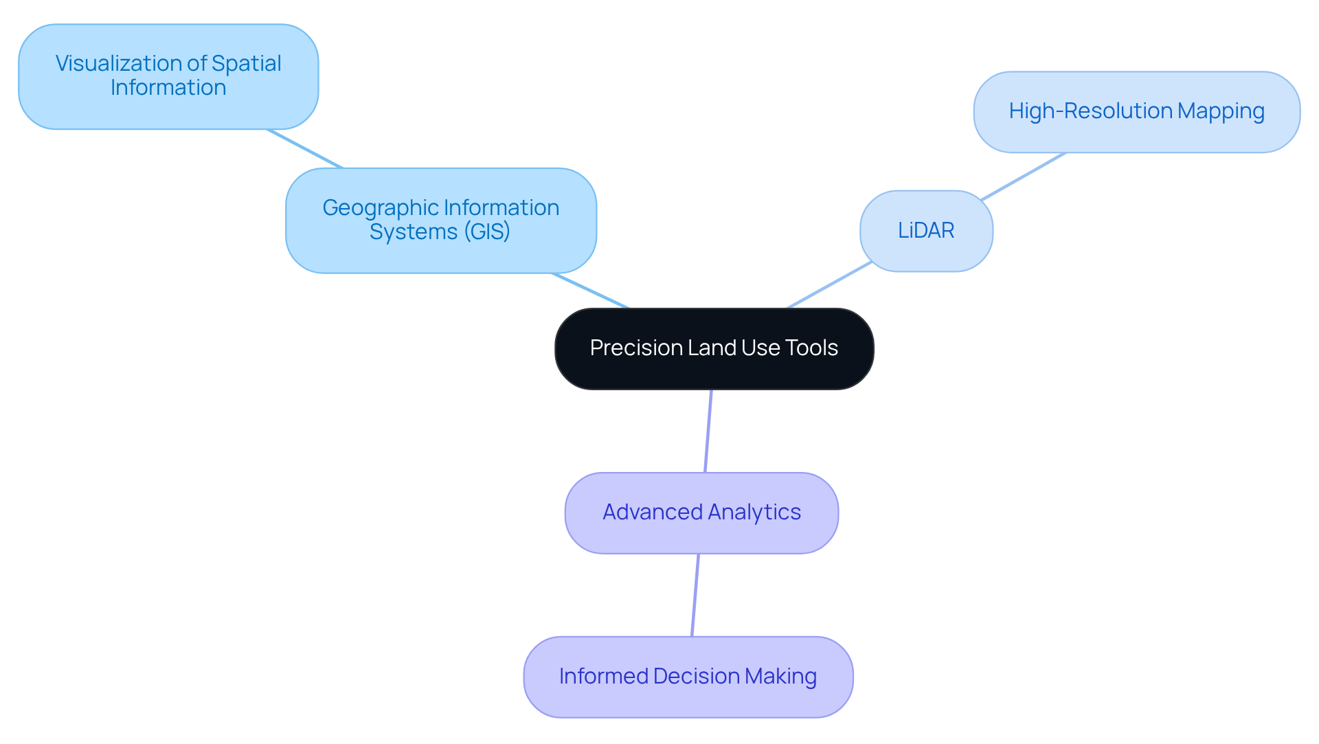
Precision resource utilization instruments are vital technologies and methodologies designed to enhance management and acquisition processes in the complex realm of land acquisition. These instruments include:
- Geographic Information Systems (GIS)
- LiDAR (Light Detection and Ranging)
- Advanced analytics
Understanding these resources is crucial for developers, as precision land use tools for developers provide essential insights into terrain attributes, zoning laws, and ecological impacts.
For instance, LiDAR technology delivers high-resolution mapping capabilities that significantly improve site assessments, enabling developers to make informed decisions swiftly. In addition, GIS applications allow for the visualization of spatial information, aiding in the identification of potential usage conflicts and opportunities for development.
Overall, these resources are indispensable for ensuring that property procurement strategies are both efficient and effective. By leveraging precision land use tools for developers, they can navigate the complexities of land acquisition with confidence, ultimately leading to more successful outcomes.

Integrate Precision Tools into Your Land Acquisition Strategy
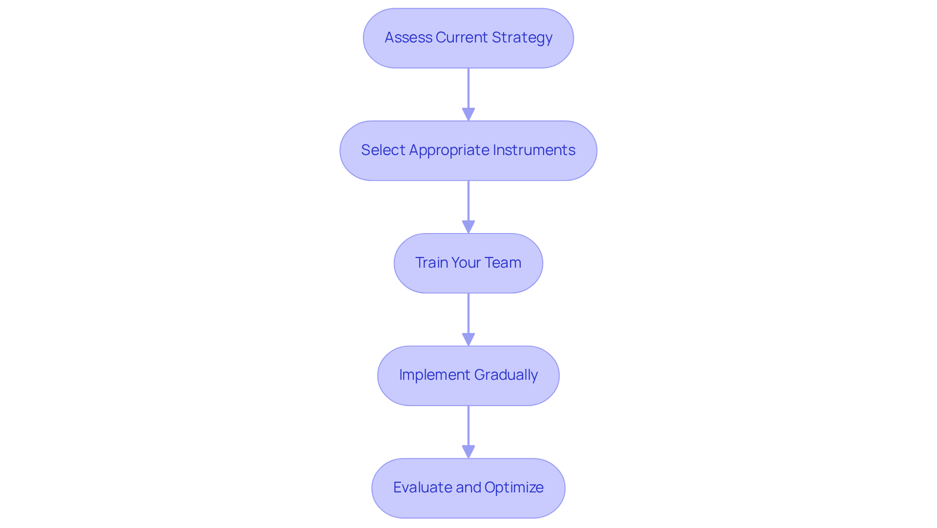
To effectively integrate precision tools into your land acquisition strategy, it is essential to follow these steps:
-
Assess Your Current Strategy: Begin by evaluating your existing land acquisition processes. Identify areas where precision land use tools for developers could enhance efficiency, especially in site selection and regulatory compliance.
-
Select Appropriate Instruments: Choose the right precision instruments tailored to your specific needs. For instance, if detailed topographical data is required, consider utilizing LiDAR technology. Conversely, if spatial analysis is critical, GIS software may be more suitable.
-
Train your team to ensure they are proficient in using precision land use tools for developers. Conduct training sessions to familiarize them with the software and methodologies, emphasizing their practical applications in land acquisition.
-
Implement Gradually: Start by incorporating one or two resources into your workflow. Monitor their impact on your processes and make adjustments as necessary. A gradual implementation allows for smoother transitions and minimizes disruptions.
-
Evaluate and Optimize: Regularly assess the effectiveness of the integrated resources. Gather feedback from your team and stakeholders to identify areas for improvement. Consistently refining your approach will ensure that you are leveraging the full capabilities of precision instruments.

Overcome Challenges in Land Acquisition with Precision Tools
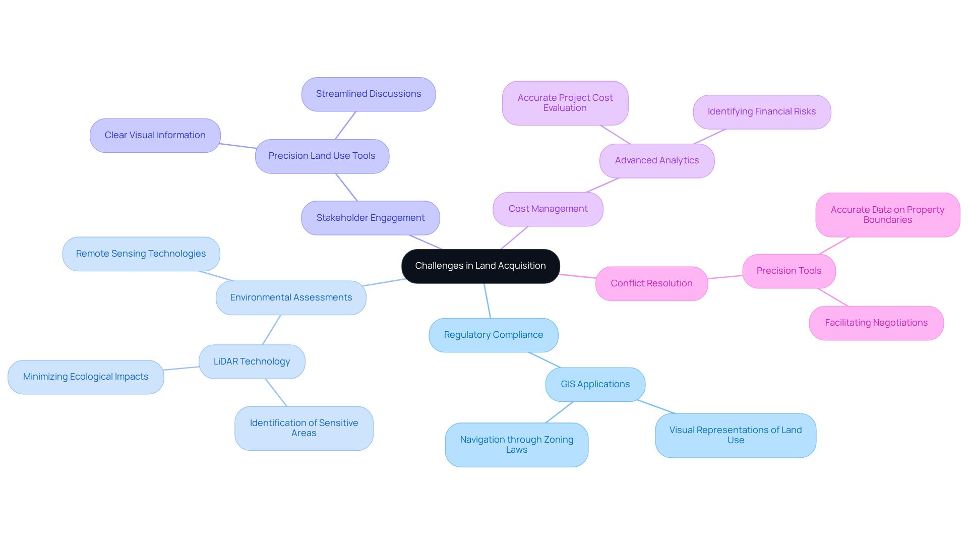
Land acquisition frequently poses significant challenges, encompassing regulatory hurdles, environmental concerns, and stakeholder opposition. Precision tools emerge as vital resources to mitigate these issues effectively:
-
Regulatory Compliance: GIS applications facilitate navigation through complex zoning laws and regulations by providing visual representations of land use and zoning classifications. This capability empowers developers to ensure compliance and avert potential legal complications.
-
Environmental Assessments: The deployment of LiDAR and remote sensing technologies enables comprehensive environmental assessments. These tools can identify sensitive areas, such as wetlands or protected habitats, allowing developers to plan strategically and minimize ecological impacts.
-
Stakeholder Engagement: Precision land use tools for developers enhance communication with stakeholders by providing clear visual information. For example, presenting development plans through GIS maps can streamline discussions with community members and local authorities, promoting transparency and collaboration.
-
Cost Management: By leveraging advanced analytics, developers can accurately evaluate project costs and identify potential financial risks early in the procurement process. This proactive strategy fosters informed budgeting and resource allocation.
-
Conflict Resolution: Precision tools aid in pinpointing and resolving property use disputes by providing accurate data on property boundaries and current usage. This clarity facilitates negotiations and diminishes conflicts among stakeholders.

Explore Additional Resources and Tools for Effective Land Acquisition
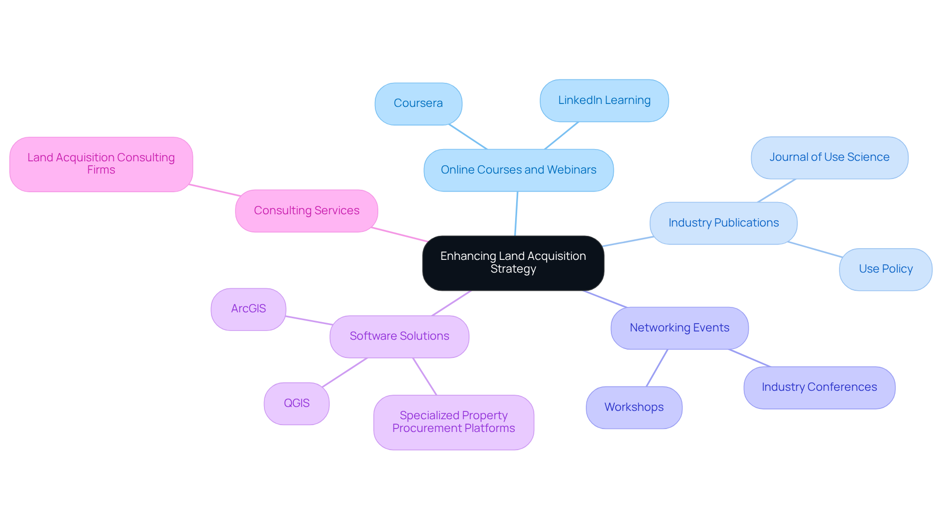
To elevate your land acquisition strategy, it is essential to explore various resources and tools that can enhance your approach:
-
Online Courses and Webinars: Platforms like Coursera and LinkedIn Learning offer courses on GIS, usage planning, and precision agriculture. These resources can equip your team with valuable insights and skills.
-
Industry Publications: Subscribing to journals and magazines focused on management and development, such as the Journal of Use Science or Use Policy, can provide access to case studies and research on the latest trends and technologies.
-
Networking Events: Attending industry conferences and workshops allows you to connect with other professionals in property development. Such networking can lead to valuable partnerships and knowledge sharing.
-
Software Solutions: Investigate innovative software options like ArcGIS, QGIS, and specialized property procurement platforms that include precision land use tools for developers, facilitating mapping, data analysis, and project management.
-
Consulting Services: Engaging with consulting firms that specialize in land acquisition and management can yield tailored strategies and insights specific to your projects.
By leveraging these resources, you can navigate the complexities of land acquisition more effectively and enhance your strategic outcomes.

Conclusion
Precision land use tools are indispensable for developers who seek to navigate the complexities of land acquisition with enhanced efficiency and success. By integrating technologies such as Geographic Information Systems (GIS), LiDAR, and advanced analytics into their strategies, developers can gain valuable insights that significantly enhance decision-making and streamline processes.
This article underscores the critical role these tools play in addressing the myriad challenges encountered during land acquisition, including:
- Regulatory compliance
- Environmental assessments
- Stakeholder engagement
By leveraging precision tools, developers can ensure adherence to zoning laws while minimizing ecological impacts and fostering transparent communication with communities. Furthermore, the strategic application of these technologies aids in cost management and conflict resolution, ultimately leading to more informed and effective land procurement strategies.
Incorporating precision land use tools transcends mere technical upgrades; it signifies a fundamental shift in how developers approach land acquisition. Embracing these technologies can markedly improve project outcomes and promote a more sustainable and collaborative development process. As the real estate landscape continues to evolve, it is imperative for developers to stay informed and adapt to these advancements to achieve long-term success in their projects.
Frequently Asked Questions
What are precision land use tools?
Precision land use tools are technologies and methodologies designed to enhance management and acquisition processes in land acquisition. They include Geographic Information Systems (GIS), LiDAR (Light Detection and Ranging), and advanced analytics.
Why are precision land use tools important for developers?
These tools provide essential insights into terrain attributes, zoning laws, and ecological impacts, which are crucial for informed decision-making in land acquisition and development.
How does LiDAR technology benefit developers?
LiDAR technology offers high-resolution mapping capabilities that significantly improve site assessments, enabling developers to make informed decisions quickly.
What role does GIS play in land acquisition?
GIS applications allow for the visualization of spatial information, helping developers identify potential usage conflicts and opportunities for development.
How do precision land use tools contribute to successful land acquisition outcomes?
By leveraging these tools, developers can navigate the complexities of land acquisition more efficiently and effectively, leading to more successful outcomes in their property procurement strategies.


