Overview
Drone-based land surveys are revolutionizing the property acquisition process, delivering remarkable advantages such as speed, cost-effectiveness, safety, and high-quality data collection. These benefits arise from the advanced capabilities of drones, which enable them to cover extensive areas swiftly and gather precise measurements. This not only enhances decision-making but also significantly boosts operational efficiency in land acquisition projects.
As stakeholders navigate the complexities of land acquisition, including legal and regulatory challenges, the integration of drone technology stands out as an effective solution. By embracing these innovations, organizations can streamline their processes and achieve superior outcomes.
Introduction
In the rapidly evolving landscape of land surveying, drone technology is emerging as a game changer, offering unprecedented capabilities that streamline processes and enhance data accuracy. As unmanned aerial vehicles (UAVs) gain traction, professionals in land acquisition are discovering the myriad advantages of integrating drones into their workflows. From the ability to cover vast areas in record time to the precision of high-resolution imaging, the benefits are compelling.
However, navigating the complexities of regulations, technology integration, and public perception remains a challenge. This article delves into the transformative role of drone technology in land surveys, exploring its benefits, methodologies, and the future trends that promise to reshape the industry.
Understanding Drone Technology in Land Surveys
Drones, or unmanned aerial vehicles (UAVs), have revolutionized surveying through drone-based land surveys, providing advanced capabilities via high-resolution imaging and data collection. Equipped with sophisticated sensors and cameras, these UAVs excel in tasks such as photogrammetry, LiDAR scanning, and topographic mapping. By 2025, the landscape of UAV technology in site surveying will feature a diverse array of UAV types, including fixed-wing and multi-rotor designs, each offering unique advantages tailored to specific surveying needs.
Understanding the capabilities of these unmanned aerial vehicles is essential for property acquisition specialists. Fixed-wing aircraft are optimal for covering extensive regions swiftly, making them suitable for large-scale land assessments. In contrast, multi-rotor vehicles provide enhanced maneuverability, making them ideal for detailed inspections in confined spaces. The choice of unmanned aerial vehicle directly influences the quality and efficiency of the survey, emphasizing the necessity for informed decision-making.
Furthermore, the integration of advanced software for processing aerial data is vital for generating accurate maps and models. The analytics market for unmanned aerial vehicles is projected to grow at a compound annual growth rate (CAGR) of 26.4% from 2023 to 2033, with revenues expected to reach USD 53.9 billion by 2033. This surge indicates a rising demand for sophisticated data processing tools, reflecting the expanding applications of UAV advancements across various sectors, including energy and infrastructure.
Public sentiment in the United States presents a divided perspective on unmanned aerial vehicles, with 54% disapproving and 46% approving of aerial strikes. This division underscores the importance of addressing societal perceptions as UAVs become increasingly prevalent in terrain surveying.
The effectiveness of drone-based land surveys in enhancing project outcomes is evident in practical applications. For instance, adherence to aviation regulations and securing necessary permits for unmanned aerial vehicle operations ensures safe and lawful usage, allowing businesses to leverage aerial capabilities while mitigating legal risks. As noted by SITECH Southwest, a leading solutions provider, "Our goal is a positive relationship with every client — we’re always willing to work with you whenever you need our expertise."
This statement highlights the importance of maintaining strong client relationships in the realm of unmanned aerial vehicles.
As surveying experts continue to adopt UAV innovations, staying abreast of the latest developments and understanding the various types of unmanned aerial vehicles will be crucial in maximizing the benefits of this cutting-edge method.
Benefits of Drone Surveys for Land Acquisition
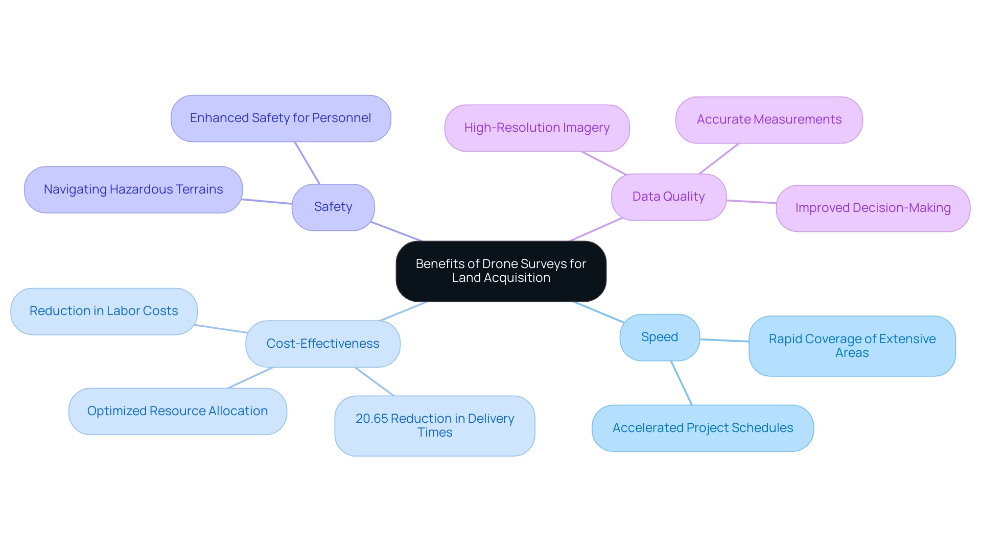
Drone assessments present a transformative array of benefits that are revolutionizing property acquisition procedures:
- Speed: Drones effectively cover extensive regions, completing evaluations in a fraction of the time required by traditional methods. This capability significantly accelerates project schedules, facilitating quicker decision-making and execution.
- Cost-Effectiveness: The integration of aerial devices can yield considerable savings in property acquisition projects. By decreasing the reliance on extensive labor and minimizing equipment costs, organizations can optimize resource allocation. Notably, drone-assisted delivery has demonstrated a reduction in delivery times by 20.65%, translating into lower operational expenses.
- Safety: Drones excel in navigating challenging or hazardous terrains without jeopardizing personnel safety. This not only enhances the safety of assessment operations but also allows for comprehensive data collection in areas that could pose risks to human assessors.
- Data Quality: Fitted with advanced imaging technology, unmanned aerial vehicles capture high-resolution imagery and provide accurate measurements. This results in improved data quality, which is crucial for precise area evaluations and informed decision-making.
The advantages of drone-based land surveys extend beyond immediate project efficiencies. A case study on wildlife monitoring utilizing aerial technology integrated with GIS exemplifies how these devices can support effective management strategies by supplying vital data for conservation efforts. This case study underscores the potential of drone-based land surveys to enhance property acquisition processes by ensuring effective management of environmental factors.
As the global aerial mapping market is projected to grow at a compound annual growth rate (CAGR) of 19.3% from 2023 to 2033, driven by the demand for reduced costs and improved outcomes, it is clear that the adoption of aerial assessments signifies not merely a trend but a pivotal evolution in the industry. Expert insights, including those from Steve Shepley of Deloitte Consulting LLP, emphasize that the engineering and construction sectors are increasingly reaping benefits from government investments in these technological advancements, which promise to boost productivity and resource allocation in property acquisition projects. Furthermore, ongoing technological progress will continue to modernize the construction sector, further solidifying the role of aerial inspections in enhancing property acquisition efficiency.

Overcoming Barriers to Drone Adoption in Land Surveys
Drone technology presents significant advantages for land surveys; however, several barriers can impede its widespread adoption.
- Regulatory Compliance: The landscape of drone operations is governed by a complex web of regulations at both local and federal levels. Professionals in land acquisition must remain vigilant and informed about these evolving laws to ensure compliance. As of 2025, navigating these regulations is increasingly critical, with the potential for new rules that could impact operational capabilities.
- Training and Skill Development: Proficient unmanned aerial vehicle operation necessitates specialized training. Organizations may find it essential to invest in comprehensive training programs that equip their teams with the necessary skills to operate unmanned aerial vehicles effectively. This investment not only enhances operational efficiency but also ensures adherence to safety standards and regulatory requirements.
- Integration with Existing Workflows: Merging drone-collected data with traditional surveying practices presents its own set of challenges. Creating a smooth process that includes unmanned aerial vehicles is essential for optimizing its advantages. This integration can lead to improved data accuracy and efficiency, ultimately enhancing project outcomes.
As the unmanned aerial vehicle market is projected to reach USD 53.9 billion by 2033, addressing these obstacles is essential for property acquisition experts aiming to utilize aerial solutions effectively. Insights from industry specialists emphasize that tackling regulatory compliance challenges is crucial for realizing the full potential of drone-based land surveys in the field of surveying. Joseph D'Souza, founder of ElectroIQ, notes, "Looking forward to 2025, the LiDAR market has altogether been forecasted to have unparalleled growth due to new innovations, lower costs, and extended applications."
Moreover, advancements in fields like hyperspectral imaging and LiDAR, as demonstrated in the case study titled 'Advanced Sensing and Imaging Techniques for Drones,' are enhancing data gathering and analysis capabilities, which can assist in alleviating some of the obstacles mentioned. Additionally, the surveillance and inspection segment is expected to record the fastest CAGR, underscoring the increasing significance and efficiency of drone-based land surveys in terrain surveying.
Methodologies for Effective Drone-Based Land Surveys
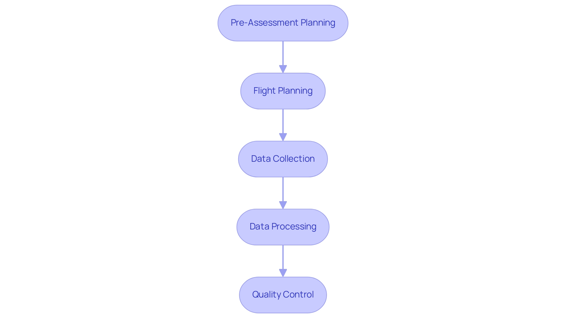
To conduct effective drone-based land surveys in 2025, professionals must adhere to proven methodologies that ensure precision and reliability:
- Pre-Assessment Planning: Clearly define the assessment area, objectives, and data requirements. A thorough site assessment is essential to identify potential obstacles such as vegetation, structures, or terrain features that could affect the evaluation.
- Flight Planning: Utilize advanced flight planning software to establish optimal flight paths, altitude, and camera settings tailored to the specific survey requirements. Fixed-wing aircraft are advantageous for larger regions due to their extended flight durations, while multi-rotor vehicles excel in thorough inspections of restricted areas. A case study on unmanned aerial vehicles for surveying highlights that the choice of vehicle type should consider factors like area size, flight time, and payload capacity to optimize surveying projects.
- Data Collection: Execute the flight plan meticulously, ensuring that the drone captures overlapping images to facilitate accurate photogrammetry. This overlap is crucial for generating high-quality 3D models and orthomosaics, essential for effective analysis.
- Data Processing: Employ specialized software to process the collected data, transforming raw images into actionable outputs such as orthomosaics and 3D models. This step is critical for deriving insights that inform land acquisition decisions.
- Quality Control: Implement rigorous quality control measures to verify the accuracy and completeness of the survey data. Regular checks and validations against known benchmarks significantly enhance the reliability of the results.
Integrating perspectives from industry leaders can further deepen the understanding of unmanned aerial vehicles' impact. Berry Mulder, Robotics Center of Excellence Leader at Shell, noted, "Great insight into the trends associated with aerial vehicle applications as well as illuminating examples, this report provided us with a great benchmark of commercial aerial applications." Additionally, Jacob Stoner, CEO of Flyeye.io, emphasizes the societal significance of unmanned aerial vehicle technology, particularly in property acquisition.
By following these best practices, property acquisition specialists can enhance their aerial surveying projects with drone-based land surveys, ensuring they meet clients' specific needs while adhering to industry standards. The importance of pre-survey planning cannot be overstated; it establishes the foundation for successful data collection and processing, ultimately leading to more informed decision-making in property acquisition. Furthermore, a report predicting the global unmanned aerial vehicle market for 2025-2030 underscores the increasing relevance of aerial systems in strategic decision-making for property acquisition professionals.

Integrating Advanced Technologies in Drone Surveys
Incorporating advanced technologies into drone-based land surveys significantly enhances efficiency in land acquisition projects.
- Artificial Intelligence (AI): The integration of AI in aerial data analysis automates the processing of assessment data, resulting in improved speed and precision. Machine learning algorithms excel at identifying patterns and anomalies, which are crucial for informed decision-making.
By 2025, the unmanned aerial vehicle sector is poised for substantial advancements in AI applications, focusing on enhancing data interpretation and operational efficiency. As Amit Ganjoo observes, the aerial vehicle industry will witness increased adoption and notable advancements toward commercial implementations of certified UTM and U-space systems, facilitating the seamless integration of unmanned aircraft into shared airspace.
- Geographic Information Systems (GIS): GIS technology is vital for analyzing and visualizing assessment data. By leveraging GIS software, acquisition professionals gain deeper insights into geographical patterns and trends, facilitating better decision-making and strategic planning. Recent statistics indicate that drone-based land surveys utilizing GIS applications are becoming essential, with a significant rise in their use for property acquisition purposes. Geographic validation suggests a cautious interpretation with a 10–30 m margin of error, underscoring the importance of precision in property acquisition.
- Real-Time Kinematic (RTK) Positioning: RTK systems offer centimeter-level accuracy, crucial for precise property assessments. This level of accuracy not only enhances the reliability of results but also supports compliance with regulatory standards. As the demand for high-precision data rises, RTK positioning is increasingly adopted in the industry.
The incorporation of drone-based land surveys represents a fundamental shift in terrain assessments. A recent case study on beach usage monitoring showcased the effectiveness of AI-powered aerial surveys, achieving up to 95% accuracy in visitor counts and 91-92% accuracy in identifying usage types. Such innovations highlight the potential for scalable and economical solutions in various property acquisition scenarios, emphasizing the importance of embracing these advancements in 2025 and beyond.
Moreover, North America leads the analytics market for unmanned aerial vehicles, illustrating the significance and competitive landscape of this technology in property acquisition within the region.
Navigating Legal and Regulatory Frameworks for Drone Surveys
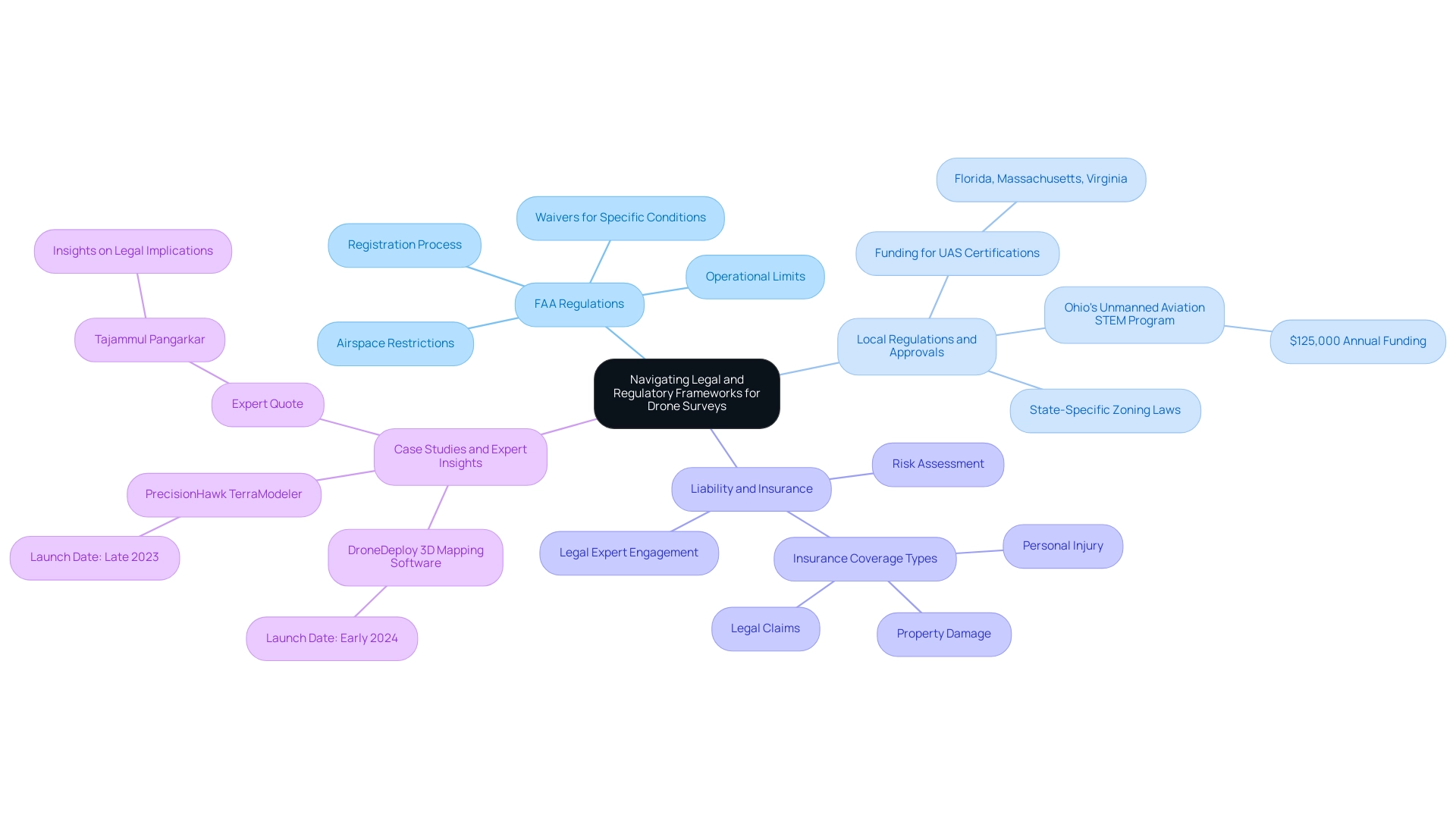
Navigating the legal and regulatory frameworks for drone-based land surveys is essential for successful land acquisition projects. Understanding these complexities is crucial for ensuring compliance and efficiency.
Understanding FAA Regulations: Familiarity with the Federal Aviation Administration (FAA) rules governing drone operations is paramount. This includes comprehending the registration process, operational limits, and the necessity of obtaining waivers for specific flight conditions. As of 2025, the FAA continues to refine its regulations, providing tools for unmanned vehicle registration and guidance on airspace restrictions, which are vital for compliance.
Local Regulations and Approvals: Beyond national guidelines, local statutes significantly influence the use of unmanned aerial vehicles in geographic assessments. Each state may have unique zoning laws and permit requirements that must be adhered to. For instance, states like Florida, Massachusetts, and Virginia have allocated funds to support UAS certifications and foster public-private partnerships, highlighting the importance of local governance in unmanned aerial vehicle operations. Furthermore, Ohio has allocated $125,000 each year to assist in the development of an unmanned aviation STEM program, underscoring the growing support for aerial technology in land assessments. Understanding these local frameworks can prevent costly delays and ensure smooth project execution for drone-based land surveys.
Liability and Insurance: Liability issues are a critical aspect of drone-based land survey operations. Assessing potential risks associated with unmanned aerial vehicle surveys and securing appropriate insurance coverage is essential to mitigate these risks. This includes coverage for property damage, personal injury, and any legal claims that may arise from the use of unmanned aerial vehicles. Engaging with legal experts who specialize in aviation law can provide valuable insights into the necessary insurance requirements and liability protections.
Case Studies and Expert Insights: Recent advancements in unmanned aerial vehicle systems, such as the launch of new 3D mapping software by DroneDeploy and precision agriculture tools by PrecisionHawk, illustrate the evolving landscape of aerial applications. These innovations not only enhance project management but also necessitate a thorough understanding of the regulatory environment to maximize their benefits. As Tajammul Pangarkar, CMO at Prudour Pvt Ltd, observes, "The incorporation of advanced methods in site surveys is transforming the industry, making it essential for professionals to remain aware of the legal implications." Engaging with industry experts can provide further clarity on navigating these legal frameworks effectively.

The Future of Drone Technology in Land Acquisition
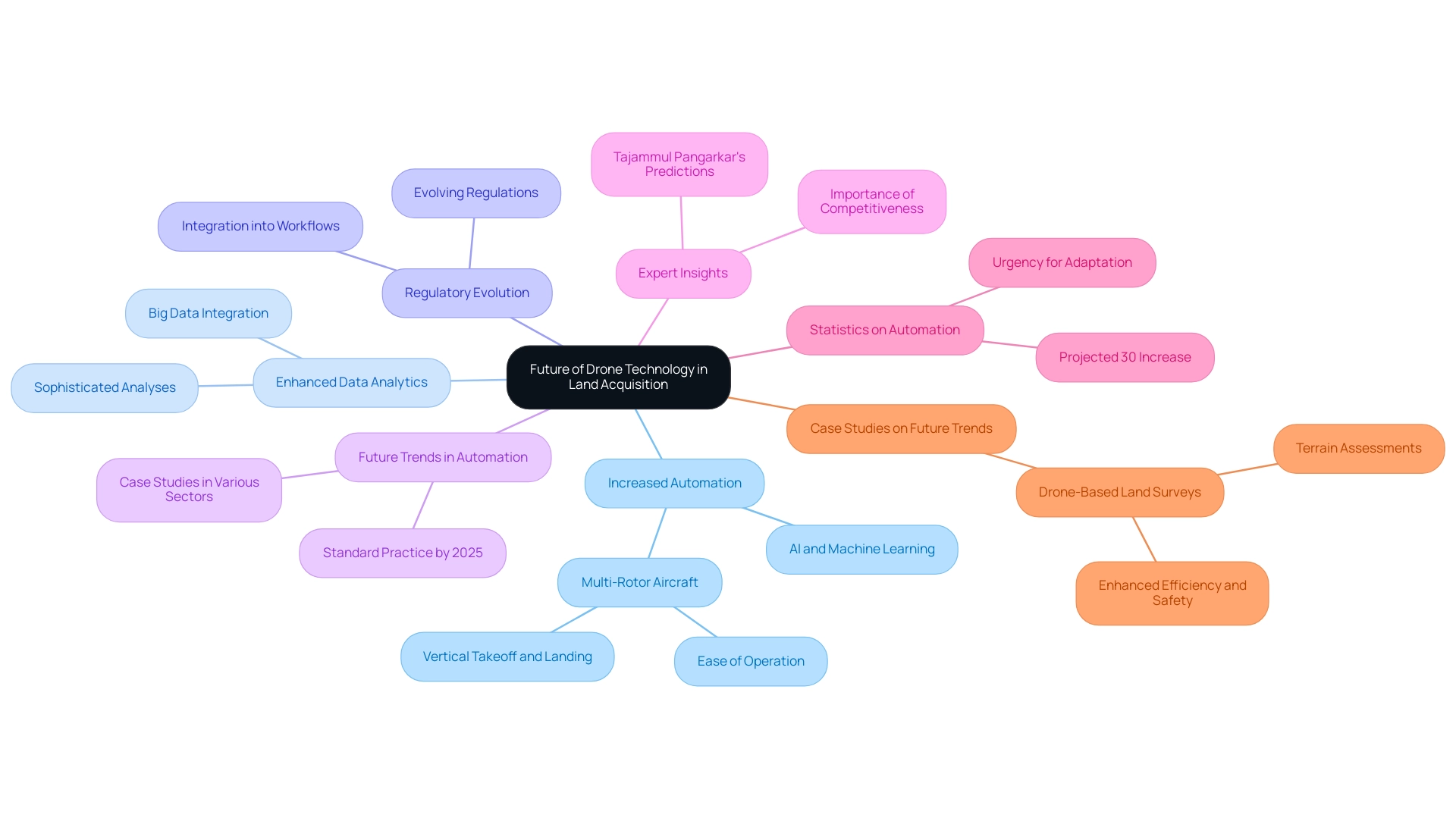
The future of aerial technology in property acquisition is set to revolutionize the industry, marked by several emerging trends:
- Increased Automation: The advancement of AI and machine learning is paving the way for greater automation in aerial operations. This shift will significantly minimize the need for manual intervention, allowing acquisition professionals to concentrate on strategic decision-making rather than operational tasks. Multi-rotor aircraft, celebrated for their ease of operation and transport, will play a crucial role in this automation, enabling vertical takeoff and landing without the necessity for dedicated infrastructure.
- Enhanced Data Analytics: The integration of big data analytics into surveying processes will facilitate more sophisticated analyses of collected data. This capability will yield deeper insights and bolster decision-making, thereby enhancing the overall efficiency of property acquisition efforts.
- Regulatory Evolution: As unmanned aerial vehicle innovation continues to mature, an evolution in regulations is anticipated. These changes will likely promote easier adoption and integration of unmanned aerial vehicles into existing workflows, empowering professionals to harness the full potential of this technology.
- Future Trends in Automation: By 2025, automation in aerial surveying is expected to become standard practice, with case studies showcasing successful implementations across various sectors. This trend will not only streamline operations but also enhance accuracy and reduce costs. Notably, the building sector is progressively embracing innovations such as drone-based land surveys, which enable precise surveying and instantaneous monitoring, making digital transformation essential for future expansion.
- Expert Insights: Industry specialists predict that the ongoing incorporation of automation will reshape operational structures in property acquisition. Tajammul Pangarkar, CMO at Prudour Pvt Ltd, emphasizes that adopting these innovations will be vital for maintaining competitiveness in an increasingly digital environment.
- Statistics on Automation: Recent research indicates that automation in unmanned aerial vehicle operations is projected to rise by over 30% in the coming years, underscoring the urgency for professionals to adapt to these developments.
- Case Studies on Future Trends: Significant case studies illustrate how companies are effectively utilizing drone-based land surveys for terrain assessments, highlighting the tangible advantages of embracing these innovations. For example, the construction sector's use of drones has resulted in enhanced efficiency and safety on job sites, demonstrating the practical applications of these advancements.
In summary, the trajectory of drone technology in land acquisition points towards a future characterized by enhanced automation, improved data analytics, and evolving regulatory frameworks, all of which will significantly impact how land acquisition professionals operate.

Conclusion
The integration of drone technology in land surveying represents a pivotal moment in the industry, transforming traditional practices into more efficient and precise methodologies. Drones provide remarkable benefits—speed, cost-effectiveness, enhanced safety, and superior data quality—that collectively expedite land acquisition processes and improve decision-making. As these unmanned aerial vehicles become increasingly sophisticated, the demand for advanced data processing tools continues to rise, reflecting the broader trend of technological evolution in land surveys.
However, the journey toward widespread drone adoption is not without challenges. Regulatory compliance, the necessity for specialized training, and the integration of drone data with existing workflows present significant barriers that professionals must navigate. Addressing these challenges is crucial for maximizing the potential of drone technology and ensuring successful project outcomes. The future of drone surveys is bright, with automation and advanced analytics poised to further revolutionize land acquisition strategies.
In conclusion, embracing drone technology and its associated advancements is essential for land acquisition professionals aiming to stay competitive in a rapidly evolving landscape. By understanding the benefits, overcoming barriers, and adopting best practices, stakeholders can harness the full power of drones, paving the way for a more efficient and accurate approach to land surveying. The commitment to integrating these innovations will undoubtedly shape the future of the industry, enabling smarter, more informed decisions that benefit both clients and communities alike.
Frequently Asked Questions
What are drones and how have they impacted surveying?
Drones, or unmanned aerial vehicles (UAVs), have revolutionized surveying by providing advanced capabilities through high-resolution imaging and data collection, enhancing tasks such as photogrammetry, LiDAR scanning, and topographic mapping.
What types of UAVs are expected to be prominent in site surveying by 2025?
By 2025, a diverse array of UAV types, including fixed-wing and multi-rotor designs, will be featured in site surveying, each offering unique advantages tailored to specific surveying needs.
How do fixed-wing and multi-rotor UAVs differ in their applications?
Fixed-wing UAVs are optimal for covering large areas quickly, suitable for extensive land assessments, while multi-rotor UAVs provide enhanced maneuverability, making them ideal for detailed inspections in confined spaces.
Why is the choice of UAV important in surveying?
The choice of UAV directly influences the quality and efficiency of the survey, making informed decision-making essential for property acquisition specialists.
What role does software play in drone-based land surveys?
Advanced software for processing aerial data is vital for generating accurate maps and models, which enhances the effectiveness of drone-based land surveys.
What is the projected growth of the UAV analytics market?
The UAV analytics market is projected to grow at a compound annual growth rate (CAGR) of 26.4% from 2023 to 2033, with revenues expected to reach USD 53.9 billion by 2033.
How does public sentiment in the United States reflect on UAV usage?
Public sentiment is divided, with 54% disapproving and 46% approving of aerial strikes, indicating the importance of addressing societal perceptions as UAVs become more prevalent in surveying.
What are some benefits of drone assessments in property acquisition?
Benefits include speed in covering extensive regions, cost-effectiveness by reducing labor and equipment costs, enhanced safety by navigating hazardous terrains, and improved data quality through advanced imaging technology.
Can you provide an example of how drone surveys can support environmental management?
A case study on wildlife monitoring using aerial technology integrated with GIS illustrates how drones can provide vital data for effective management strategies in conservation efforts.
What is the expected growth of the global aerial mapping market?
The global aerial mapping market is projected to grow at a CAGR of 19.3% from 2023 to 2033, driven by demand for reduced costs and improved outcomes in property acquisition.
How are government investments influencing the use of UAVs in engineering and construction?
Government investments in UAV technology are boosting productivity and resource allocation in property acquisition projects, highlighting the increasing benefits for the engineering and construction sectors.
List of Sources
- Understanding Drone Technology in Land Surveys
- Drone Analytics Statistics and Facts (2025) (https://scoop.market.us/drone-analytics-statistics)
- 10 Best Drones for Mapping in 2025 (A Complete Buying Guide) (https://jouav.com/blog/drone-for-mapping.html)
- Maximizing Business Potential with Drone Surveying Tactics (https://sitechsw.com/how-drones-enhance-surveying-business)
- Benefits of Drone Surveys for Land Acquisition
- Advancements and Applications of Drone-Integrated Geographic Information System Technology—A Review (https://mdpi.com/2072-4292/15/20/5039)
- 2025 Engineering and Construction Industry Outlook (https://www2.deloitte.com/us/en/insights/industry/engineering-and-construction/engineering-and-construction-industry-outlook.html)
- Drone Technology Advancement for Performing Growing Number of Tasks and Usage Leading to Revenue Growth (https://globenewswire.com/news-release/2025/02/27/3033960/0/en/Drone-Technology-Advancement-for-Performing-Growing-Number-of-Tasks-and-Usage-Leading-to-Revenue-Growth.html)
- ZenaTech, Inc. Signs LOI to Acquire Land Survey Engineering Company in Arizona as Part of DaaS Expansion (https://nasdaq.com/articles/zenatech-inc-signs-loi-acquire-land-survey-engineering-company-arizona-part-daas-expansion)
- Overcoming Barriers to Drone Adoption in Land Surveys
- Drone Analytics Statistics and Facts (2025) (https://scoop.market.us/drone-analytics-statistics)
- LiDAR Statistics By Market Size and Facts (https://electroiq.com/stats/lidar-statistics)
- Commercial Drones Statistics and Facts (2025) (https://scoop.market.us/commercial-drones-statistics)
- Drone Data Services Market Size, Industry Trends | 2032 (https://consegicbusinessintelligence.com/drone-data-services-market)
- Methodologies for Effective Drone-Based Land Surveys
- Drones for Surveying: How They Work and Their Applications - YellowScan (https://yellowscan.com/knowledge/drones-for-surveying)
- Drone Industry Insights | Global Drone Market Research (https://droneii.com/?srsltid=AfmBOoqPVbn-Itc2qG_F_IKaR2dkW1K7-nIvTbmUu8h5dF0Ajj6KvRmV)
- Revolutionizing Surveying: The Rise of Drones (March 2025) (https://flyeye.io/revolutionizing-surveying-the-rise-of-drones)
- Integrating Advanced Technologies in Drone Surveys
- Drone Analytics Statistics and Facts (2025) (https://scoop.market.us/drone-analytics-statistics)
- Drone Insights: Unveiling Beach Usage through AI-Powered People Counting (https://mdpi.com/2504-446X/8/10/579)
- 2025 Drone Industry Predictions: What’s Coming Next in Policy, Tech, and Global Markets (https://dronelife.com/2025/02/07/2025-drone-industry-predictions-whats-coming-next-in-policy-tech-and-global-markets)
- Navigating Legal and Regulatory Frameworks for Drone Surveys
- Current Unmanned Aircraft State Law Landscape (https://ncsl.org/transportation/current-unmanned-aircraft-state-law-landscape)
- faa.gov (https://faa.gov/uas)
- Drone Analytics Statistics and Facts (2025) (https://scoop.market.us/drone-analytics-statistics)
- The Future of Drone Technology in Land Acquisition
- 2025 Engineering and Construction Industry Outlook (https://www2.deloitte.com/us/en/insights/industry/engineering-and-construction/engineering-and-construction-industry-outlook.html)
- Drone Technology: Future Trends and Practical Applications [1 ed.] 1394166532, 9781394166534 - DOKUMEN.PUB (https://dokumen.pub/drone-technology-future-trends-and-practical-applications-1nbsped-1394166532-9781394166534.html)
- Experts Say the ‘New Normal’ in 2025 Will Be Far More Tech-Driven, Presenting More Big Challenges (https://pewresearch.org/internet/2021/02/18/experts-say-the-new-normal-in-2025-will-be-far-more-tech-driven-presenting-more-big-challenges)
- Drone Analytics Statistics and Facts (2025) (https://scoop.market.us/drone-analytics-statistics)


