Introduction
The integration of a robust land management system is crucial for effective land acquisition and sustainable resource management. This article explores the importance of such a system and its key features, as well as the role of automation and Geographic Information Systems (GIS) in land management. By implementing advanced methodologies and technologies, organizations can address environmental and social concerns, streamline processes, and make data-driven decisions.
Examples from Cedar Rapids and Danone demonstrate the success of strategic land management systems, while developments in land registration systems highlight the impact of technology. Furthermore, the article discusses the transformative power of automation in industries like meat processing and agriculture, emphasizing its potential to increase productivity and address future challenges. The integration of GIS enables spatial analysis and informed decision-making, as showcased by case studies in climate change, environmental restoration, and societal issues.
Overall, this article highlights the importance of a comprehensive land management system and the benefits it brings to various sectors.
The Importance of a Robust Land Management System
Executing a comprehensive system for handling acquired property is essential for its effective operation. This system equips organizations with the necessary resources to handle the complexities of acquiring property, from the initial phases of strategy formulation to the conclusion of the transaction. By integrating advanced methodologies, such as those observed in landscape and jurisdictional approaches, organizations can address environmental governance and social concerns at a broader scale. These approaches consider the interconnectedness of ecosystems, acknowledging that changes in one area can impact adjacent regions, thus promoting sustainable utilization of resources.
For instance, the partnership between the city of Cedar Rapids and Forerunner stands as proof of the effectiveness of strategic control systems for the use of land. After enduring a devastating flood, Cedar Rapids revamped its strategies for overseeing its territory, which now function as a dynamic and proactive blueprint for others confronting comparable climate obstacles. Similarly, Danone's initiative to work with 58,000 farmers globally to reduce methane emissions demonstrates the power of a systems approach to facilitate change across research, policy, market coalitions, supply chains, and farms.
Recent advancements in registration systems for properties, similar to those observed in Kaduna and Nasarawa states, highlight the significance of technology in property management. The integration of Geographic Information Systems has not only improved property registration rates but has also led to significant revenue generation. This aligns with the efforts mentioned at the World Economic Forum in Davos to encourage private sector involvement in habitat restoration before COP16. Such initiatives showcase the potential of combining technology with strategic planning to enhance urban resilience and tackle socio-economic and environmental challenges.
The World Bank's commitment to supporting a National Digital Land Information System in Nigeria reflects the global understanding of the importance of robust administration systems. The objective to formalize property transactions and enhance titled real estate showcases the transformative influence that such systems can have on administration of land. According to the report on Environmental Health and Restoration by the Chesapeake Bay Program, achieving sustainability and restoration necessitates a vast network of partners, an important concept that can be applied to land-based systems aiming to enhance decision-making and provide crucial land-related services.
Key Features of an Effective Land Management System
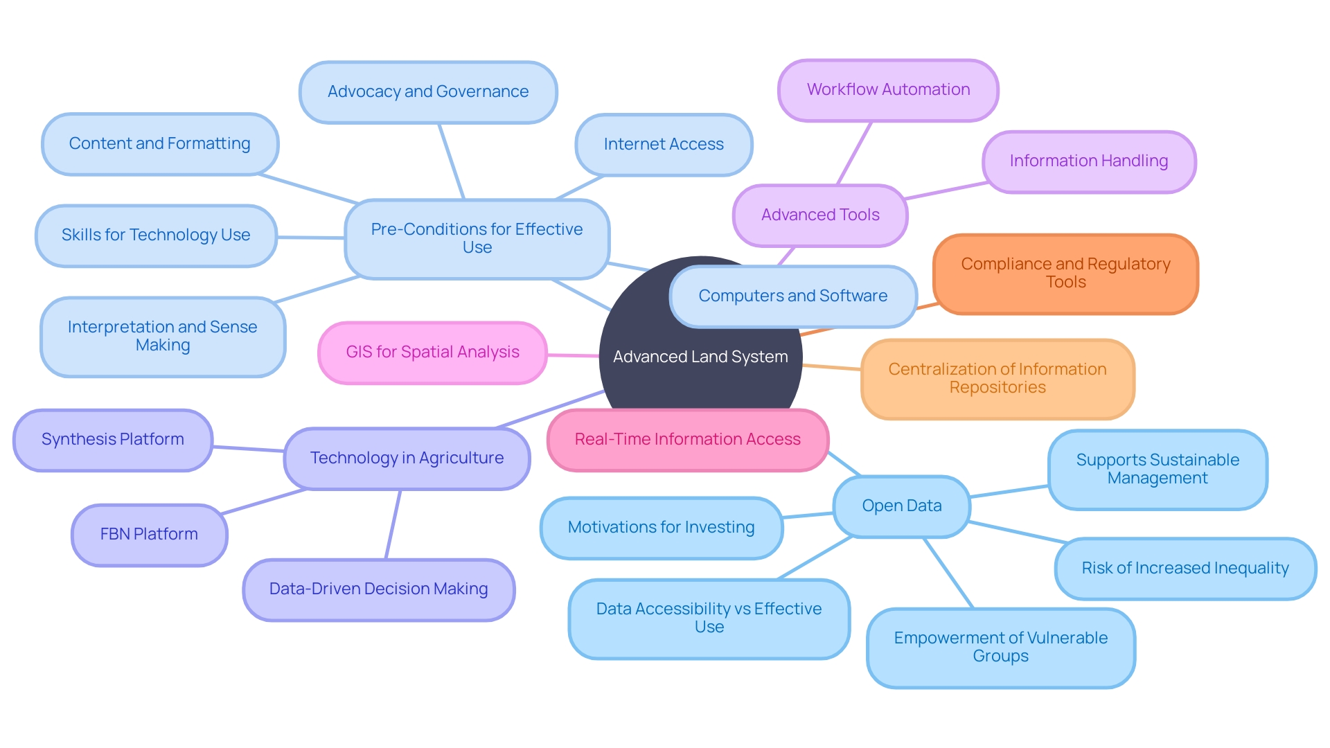
An advanced land system is crucial for streamlining the land acquisition process, and its effectiveness depends on several essential features. Among these are the integration of advanced tools for handling information, the automation of regular workflows, and the incorporation of Geographic Information Systems (GIS) for spatial analysis. Additionally, real-time information access and comprehensive tools for managing compliance and regulatory requirements are essential components. Such a system empowers organizations to centralize their information repositories, automate procedural tasks, scrutinize spatial information, maintain the integrity of their information, and navigate the complexities of legal and regulatory frameworks with greater efficiency.
The significance of these characteristics is emphasized by the wider context of open information's function in property administration, which aims to promote sustainable socio-economic and environmental management. However, the utilization of open information can also pose risks, such as exacerbating inequality, particularly if open data empowers those already in advantageous positions. For example, in Bangalore, India, the digitization of land records enabled wealthier individuals and corporations to exploit documentation errors and navigate land ownership challenges to their advantage, often to the detriment of less affluent landholders.
To minimize such risks and exploit the complete potential of open information for the advantage of all, it is essential to establish pre-conditions for its efficient use. This includes ensuring that a wide range of users has the resources and opportunities to convert open information into meaningful outcomes. Ensuring fair access to the internet, computers, software, and the necessary skills to interpret and apply information is crucial. Additionally, promoting a culture of support and management around information utilization can aid in avoiding the misuse of accessible information against marginalized communities.
In the agricultural sector, the integration of technology has revolutionized traditional farming practices. Platforms like Synthesis, which synthesizes a wide range of information from diverse sources into actionable intelligence, exemplify the transformative power of digital tools. This approach, informed by advanced algorithms, creates digital twins of fields, enabling predictive analytics that guide farmers in making precise, data-driven decisions.
The sweeping benefits of such technologies are evident in the growth of networks like FBN, which supports farmers through a comprehensive digital platform. With over 75,000 members, FBN's platform facilitates access to various farming essentials, from seeds to machinery, and leverages large-scale agricultural analysis to inform better agronomic and marketing strategies. This has resulted in the examination of 100 billion field information points, demonstrating the scalability and influence of data-driven land administration systems on the agricultural landscape.
Overall, the incorporation of essential elements into administration systems is not just about improving operational effectiveness but also about promoting fair access to information and empowering parties involved. By bridging the gap between data accessibility and effective data use, we can work towards a future where land-related services are delivered more effectively, and decision-making is significantly improved.

Automation and Efficiency in Land Management
The integration of automation into land administration is revolutionizing the industry, offering unprecedented improvements in efficiency and productivity. Take the case of John Dee's meat processing operations, where the implementation of automation technologies addressed the unique challenges posed by the random release of products. By automating the tracking, accuracy, and safety processes, John Dee significantly mitigated the inefficiencies of manual handling that were once prevalent in their operations.
Similarly, Directed Machines' Land Care Robots (LCRs) are at the forefront of agricultural innovation, performing a variety of tasks that not only address the labor shortages but also contribute to environmental sustainability. These solar-electric robots showcase the diverse advantages of automation, from minimizing physical work to providing remedies for grading and plowing, thereby emphasizing the potential for automation to revolutionize practices across various industries.
In the broader context of agricultural productivity, the importance of increasing yield cannot be overstated. With global use for agriculture spanning an impressive 48 million square kilometers, the role of automation in enhancing productivity is critical. As yields have increased from one ton of wheat per hectare to three and a half tons over the past 60 years, automation continues to push these figures further, demonstrating its capacity to meet the rising demands for food production.
Moreover, the application of machine vision and motion control in automation facilitates delicate, high-speed operations that once posed significant challenges. This advancement in quality control and operational efficiency is not only beneficial for industries like meat processing but also extends to various sectors that face similar demands for increased speed and precision.
As we consider these advancements, it is clear that automation is not just a tool for improving current processes—it is also a strategic solution to future challenges. With projections of a global food crisis on the horizon, the role of automation in agriculture becomes even more pertinent. It is a testament to the transformative power of technology in addressing some of the most pressing issues in land administration and food cultivation today.

GIS Integration for Spatial Analysis
The incorporation of Geographic Information Systems (GIS) into resource management strategies is proving to be a game-changer. GIS technology enables organizations to conduct spatial analysis, providing critical insights regarding suitability, environmental impact assessments, and infrastructure planning. The utilization of GIS enables the visualization of intricate information on maps, facilitating the analysis of spatial relationships which are vital in making data-driven decisions for land acquisition.
Case studies illustrate the transformative potential of GIS when paired with artificial intelligence (AI). For instance, a partnership between Columbia University, the University at Albany, State University of New York, and Esri is exploring how AI can bolster climate and nature solutions, highlighting GIS's role in addressing the Triple Planetary Crisis of climate change, biodiversity loss, and pollution.
In practical applications, GIS has been instrumental in projects like the UK PACT program in Kenya, which focuses on forest and landscape restoration and climate action. It demonstrates how GIS can empower local communities and drive significant environmental changes.
News of Minnesota's approach to utilizing GIS for solving complex societal issues such as child poverty, water quality, and internet accessibility further underscores the effectiveness of GIS in policy-making and governance. Similarly, geospatial initiatives provide urban planners and health professionals with tools to make informed decisions, using GIS to assess air quality and green space distribution, thus contributing to public health and sustainable urban development.
Jack Dangermond, the founder of Esri, highlights the genesis of GIS as a method to conceptualize geographic information into layers within computers—models that have undergone significant development from the field's initial stages as spatial information management. Today, GIS is ubiquitous, extending beyond personal smartphones to vital industry and scientific applications, ensuring efficient navigation, product delivery, and disaster risk assessment.
In essence, GIS has become an indispensable tool in environmental monitoring, natural disaster risk assessment, and urban planning, reflecting its widespread utility in managing the spatial data that underpin our daily lives and the functioning of societies worldwide.
Conclusion
In conclusion, a robust land management system is crucial for effective land acquisition and sustainable resource management. Implementing advanced methodologies and technologies allows organizations to address environmental and social concerns, streamline processes, and make data-driven decisions. Success stories from Cedar Rapids and Danone demonstrate the positive impact of strategic land management systems.
Key features of an effective land management system include advanced data management tools, workflow automation, and integration of Geographic Information Systems (GIS) for spatial analysis. These features enhance operational efficiency and empower stakeholders. It is important to ensure equitable access to data and mitigate risks associated with open data.
Automation revolutionizes land management, improving efficiency and productivity. Examples in meat processing and agriculture highlight the potential of automation to address challenges and increase yield. As global food demands rise, automation becomes even more important for sustainable land management and food production.
The integration of GIS enables spatial analysis and informed decision-making in land management. GIS has proven to be a game-changer in addressing climate change, biodiversity loss, and pollution. It empowers communities, facilitates policy-making, and contributes to environmental changes.
GIS is an indispensable tool in various sectors, managing spatial data and supporting societies worldwide.
In summary, a comprehensive land management system with advanced methodologies and technologies is essential for effective land acquisition and sustainable resource management. It enables organizations to address environmental and social concerns, streamline processes, and make data-driven decisions. Automation and GIS further enhance efficiency, productivity, and informed decision-making.
Embracing these tools and approaches leads to better land management outcomes and a more sustainable future.


