Introduction
Accurate land documentation plays a crucial role in land zoning, property ownership affirmation, and informed decision-making for landowners, government bodies, and developers. It guides the judicious use of land resources and directs development efforts. Open data initiatives have enhanced land administration systems, but they also bring challenges, such as the risk of exacerbating social inequalities.
The digitization of land records in Bangalore, India, highlighted how data can empower privileged groups at the expense of the marginalized. Conversely, the First Nations in Canada demonstrate how empowering vulnerable communities to manage their data can mitigate such risks. In this article, we explore the importance of land documentation, the types of documents involved, the steps to obtain them, key components, common mistakes to avoid, legal and regulatory aspects, best practices for maintenance, and the tools and resources available.
By understanding and adhering to these aspects, we can ensure secure property transactions and sustainable land management. Additionally, we examine successful case studies that illustrate the transformative power of well-maintained land documentation in facilitating equitable land transactions and supporting development.
Why Land Documentation is Important
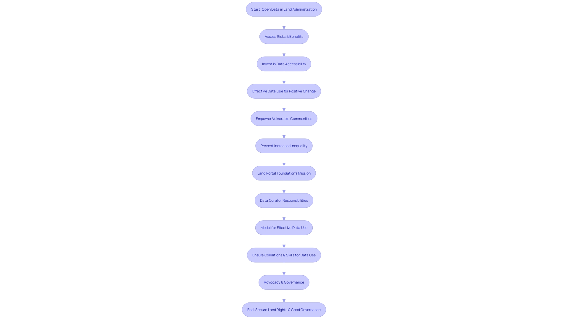
Accurate land documentation is integral to deciphering land zoning, use regulations, and affirming property ownership rights. It underpins informed decision-making for landowners, government bodies, and developers, guiding the judicious use of land resources and directing development efforts. Open data initiatives have proven instrumental in enhancing land administration systems, promoting sustainable socio-economic and environmental management. However, the democratization of data also brings challenges, notably the risk of exacerbating social inequalities. Effective data use extends beyond mere accessibility; it necessitates equitable opportunities and the necessary skills across society to leverage open data for positive change.
Illustrating this, the digitization of land records in Bangalore, India, highlighted the potential for data to empower privileged groups at the expense of the marginalized. Conversely, the First Nations in Canada exemplify how empowering vulnerable communities to manage their data can mitigate such risks. As we navigate towards a future where open data serves as a foundation for improved decision-making, it is crucial to ensure that it benefits all layers of society.
In the context of property transactions, the significance of blockchain technology is emerging as a solution to secure data integrity within land registries. Blockchain's immutable nature ensures that once recorded, data cannot be altered, providing a permanent and tamper-proof record. This technological advancement is revolutionizing how property documentation is maintained, offering a resilient alternative to traditional systems prone to data loss or corruption. As we witness frequent data breaches in major corporations, blockchain's robust security features present a compelling case for its adoption in public digital storage, particularly for critical land authority functions.
Types of Land Documentation
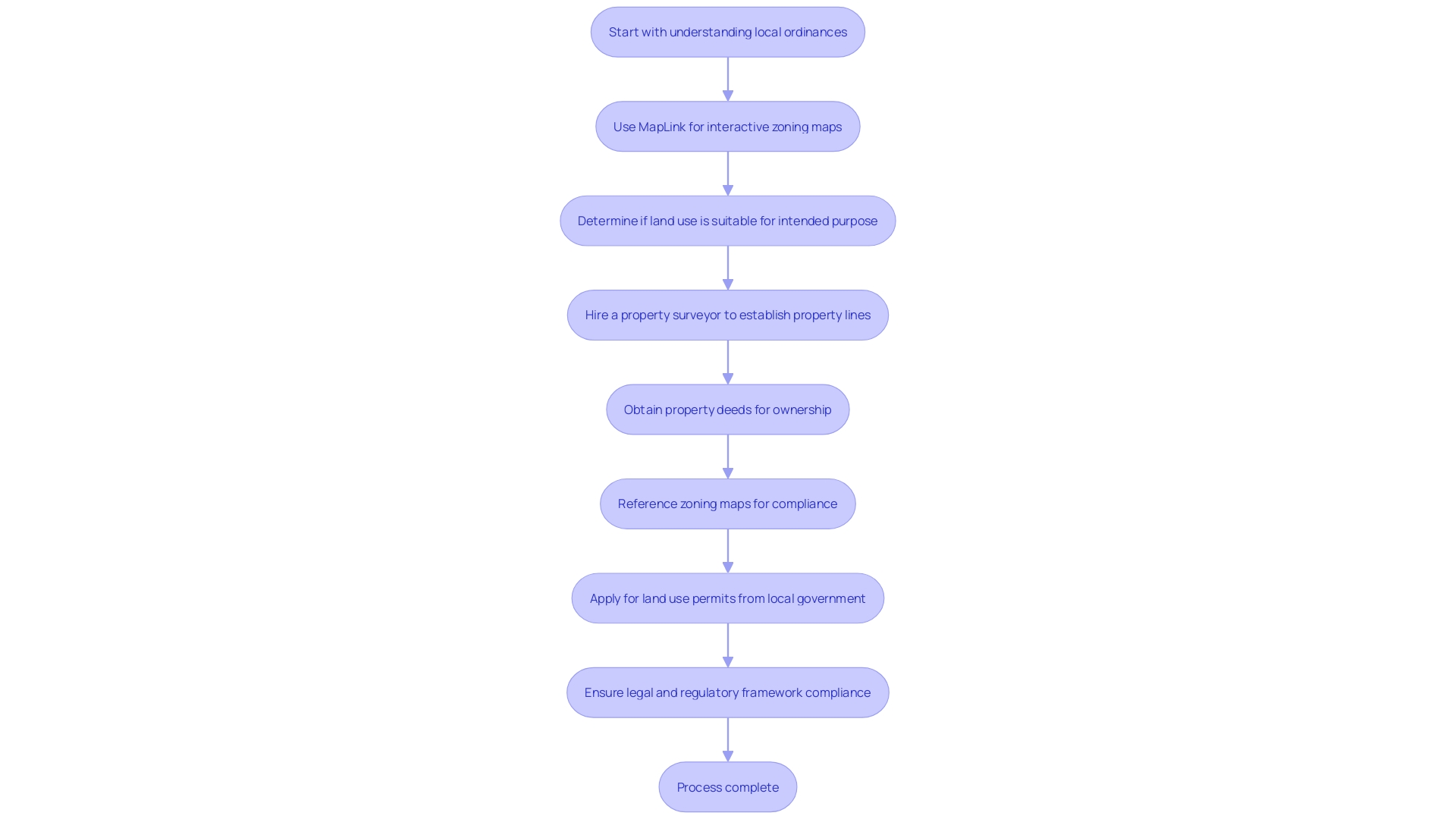
Navigating the complexities of land regulations requires a detailed understanding of various types of land documentation. Among the essential documents are land surveys, which provide precise measurements and boundaries of a property, crucial for determining zoning compliance and planning development. Property deeds are legal documents that prove ownership and include vital details such as the identity of the current and previous owner, a description of the property, and any warranties or restrictions on use. Zoning maps are authoritative guides that delineate designated uses of land within a jurisdiction, helping to ensure that developments meet community standards and regulations. Lastly, land use permits are official permissions granted by local governments that allow for certain uses of land, which may include building new structures, modifying existing ones, or changing the land's use. With real-world implications, such as those seen in the recent changes to the land laws in Vietnam and Scotland, understanding the legal and regulatory framework governing land use and ownership is not only a matter of compliance but also of strategic importance in the socio-economic and environmental landscape.

Steps to Obtain Land Documentation
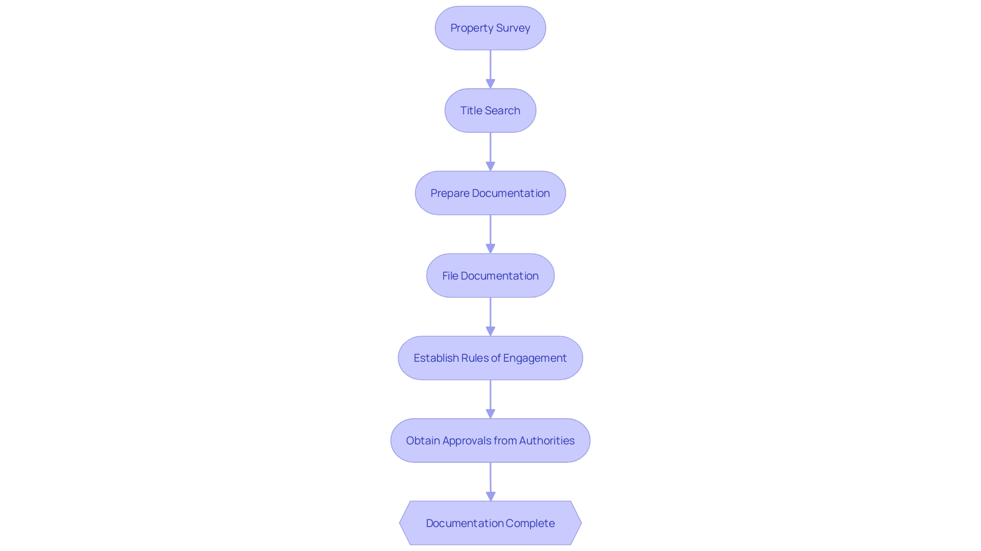
Acquiring the correct land documentation is a multi-step undertaking vital for any property transaction, ensuring legal compliance and validity. The process typically starts with a detailed property survey to establish exact boundaries and identify any physical features of the land. As cited by a seasoned Realtor, this step is crucial, especially for sellers, as it helps pinpoint property lines and is often a key request from potential buyers. A thorough title search follows, which is fundamental in verifying the seller's right to transfer ownership and in uncovering any existing encumbrances or liens on the property.
Next, preparing and filing the necessary documentation is critical. This includes a land purchase agreement, a legally binding contract that delineates the buyer and seller details, the land address, the agreed-upon purchase price and terms, and the timeline for meeting these conditions. To navigate this complex process, it's essential to consider whether a traditional land purchase agreement or an installment land contract best suits one's financial needs and circumstances.
Moreover, with advancements in technology, new methods of land ownership, such as tokenization of real-world assets on blockchain, have emerged. However, they carry their own set of risks, from technological to traditional, such as potential fraudulent actions by real estate owners. To mitigate these, establishing clear 'rules of engagement' between property owners and token holders is paramount, often formalized through a corporate resolution.
Obtaining approvals from relevant authorities is the final step, now made more rigorous with proposals like the real estate geographic targeting order (GTO) program by FinCEN, which requires detailed reporting for property transactions. This ensures transparency in the ownership transfer process and helps combat systemic issues.
Overall, whether one is dealing with traditional property transactions or navigating the newer realms of tokenized real estate, it is imperative to understand and follow the legal and regulatory requirements to ensure a secure and legitimate transfer of property rights.

Key Components of Land Documentation
Land documentation is more than just paperwork; it's the foundation of property ownership, defining the scope of what can and cannot be done on a piece of land. This includes the precise mapping of property boundaries, a critical aspect to avoid disputes and ensure clarity of ownership, as emphasized by real estate professionals who advocate for the importance of property surveys to pinpoint exact property lines.
Easements, another crucial element, grant rights to use parts of the land for specific purposes, such as utilities or access. Restrictions, on the other hand, can limit the types of structures built or the activities conducted on a property, often put in place to preserve the character of a neighborhood or adhere to zoning laws.
Encumbrances are also part of the land documentation, which could be liens or mortgages, indicating a claim on the property by a third party until a debt is paid off. There's a vast array of deeds, each with different levels of protection and guarantees, affecting the rights transferred in a property sale. For instance, a warranty deed offers more guarantees about the property's status than a quitclaim deed.
These documentation elements are vital for understanding what you can do with your land. A case in point is the historical Bruce's Beach in California, where property ownership rights were challenged, leading to the loss of a valuable asset. Similarly, legal disputes in Colombia and Mexico demonstrate the complexity of land rights when environmental regulations or national interests come into play.
The importance of these documents is further highlighted by the adoption of land disposition frameworks by councils to manage city-owned properties strategically, ensuring they serve the community's needs effectively. Staying informed about local government decisions, such as zoning by-law amendments, is also crucial, as these can affect property rights and values.
All these considerations are essential for anyone involved in land acquisition, development, or management, providing a clear picture of the permissible uses of land and the potential for future development or legal challenges.
Common Mistakes to Avoid in Land Documentation
Accurate land documentation is crucial to avoid future legal complications. Missteps such as incorrect property descriptions or outdated records can lead to disputes and undermine socio-economic and environmental management. Effective land documentation requires a comprehensive approach that integrates open data, ensuring it serves as a tool for sustainable development rather than exacerbating inequalities. Case studies, like the digitization of land records in Bangalore, India, highlight how open data can inadvertently favor those with more resources, who can exploit errors in documentation for their gain. To counteract this, it's essential to empower all stakeholders, including those in vulnerable positions, to effectively use and manage their data, as seen with the First Nations in Canada.
Recent efforts in places like Uzbekistan have underscored the importance of enhancing cadastral services through digitalization. With the introduction of private cadastral engineers and modern information systems like UZKAD, the aim is to improve land accounting and provide equitable access to cadastral services. In this regard, meticulous research, accurate filing, and the utilization of qualified surveyors become indispensable to establish clear property lines and prevent boundary disputes. With the global real estate industry recognizing the significance of precise land surveys, stakeholders must prioritize data accessibility, computer literacy, and interpretation skills to ensure land documentation reflects the true nature of the property and protects the rights of all parties involved.
Legal and Regulatory Aspects of Land Documentation
Navigating the intricacies of land documentation involves more than just understanding legal statutes; it requires a comprehensive grasp of the ever-evolving landscape of open data and its implications for land use and ownership. Open data has the potential to revolutionize land administration systems, fostering sustainable socio-economic and environmental management. However, it's not without its risks, particularly in exacerbating inequalities. To mitigate this, it's imperative to empower vulnerable communities, such as the First Nations in Canada, to manage their own data, ensuring they are not disadvantaged by open data practices.
Recent legislative developments, like the amended Land Law and Law on Credit Institutions passed by Vietnam's National Assembly, underscore the complexity and breadth of land-related legal frameworks. The revised land law, with its extensive 16 chapters and 260 articles, redefines land ownership, management, and user rights, and is set to come into effect in 2025. This kind of legislation reflects the critical nature of land laws in shaping political, economic, and environmental outcomes for nations.
The National Zoning and Land Use Database (NZLUD) is a testament to the challenges of comprehending zoning and land use laws across various jurisdictions. This database, which catalogs zoning codes for over 2,600 U.S. municipalities, provides valuable insights into restrictions like minimum lot sizes, maximum building heights, and other regulatory measures. It is an open-source, dynamic tool that continues to evolve, reflecting changes in policy and practice.
Effective data use demands more than just availability; it requires the necessary conditions, tools, and skills for diverse users to benefit equitably. This is illustrated through a model that includes internet access, computers and software, and the competencies to interpret and utilize data effectively. The goal is to ensure open data serves as a platform for positive change, rather than a tool that could potentially be used against less advantaged populations.
Understanding these various elements is critical in preventing legal disputes and ensuring adherence to guidelines. This includes awareness of national policies, such as the National Environmental Policy Act (NEPA) and its state counterparts, which, although initially designed to disclose environmental impacts, have become instruments that can significantly delay development projects and increase compliance costs.
In the realm of real estate, professionals recognize the importance of land surveys for delineating property lines and detailing land characteristics. Such precision is vital for avoiding boundary disputes, fostering harmonious relationships between neighboring landowners, and securing a clear understanding of property rights.
Zoning, often misunderstood by the general public as a simple game-like mechanism, is in reality a complex and nuanced system that profoundly influences the character and functionality of urban spaces. Somerville, Massachusetts serves as a prime example of a city where zoning, market demand, and community attributes converge, leading to high property values and reflecting the desirability of well-planned urban environments.
For those involved in land acquisition and management, staying informed about these multifaceted issues is not just beneficial—it's essential.

Best Practices for Maintaining Land Documentation
Optimizing the organization, storage, and regular updating of land documentation is pivotal to maintaining its integrity and utility over time. Utilizing digital tools and technologies can significantly enhance the efficiency of documentation management. Open data, for instance, plays a crucial role in supporting land administration systems which are essential for sustainable socio-economic and environmental management. However, it is paramount to acknowledge the risk of open data potentially exacerbating inequality. Effective use of such data hinges on ensuring that all users, especially those in vulnerable positions, have equitable access to the necessary resources and skills required for data interpretation and application.
The model for effective data use encompasses internet access, suitable devices, and software, along with the competencies to utilize these tools effectively. This involves content and formatting that can be understood, the ability to interpret and derive meaning from the data, and the capacity for advocacy and governance. This comprehensive approach is essential to prevent open data from being underutilized or misused, particularly against disadvantaged populations.
For instance, the First Nations in Canada exemplify how empowering communities to manage their own data can mitigate such risks. Similarly, advancements in digitalization within the cadastral domain, as seen with the upcoming UZKAD information system, demonstrate the commitment to improving the quality and accessibility of cadastral services through technology.
Moreover, innovative platforms like NatureHelm are setting new standards in land and biodiversity management. By providing tools for monitoring and analyzing ecosystem markers, such services are at the forefront of assisting landowners in navigating the evolving landscape of environmental regulations.
Keeping in line with these developments, ensuring that land documentation is easily accessible and accurately maintained is not only about preservation but also about fostering an environment where informed decision-making and delivery of essential land-related services are the norm. This is especially significant when considering that globally, 2.5 billion people depend on communally managed territories, which frequently lack legal protection, thereby affecting sustainability and leading to conflicts and environmental degradation.
In summary, the fusion of open data and digital technologies has the potential to revolutionize land documentation management. However, it requires a conscientious approach that prioritizes equitable access and empowerment to harness these advancements for the greater good.
Tools and Resources for Land Documentation
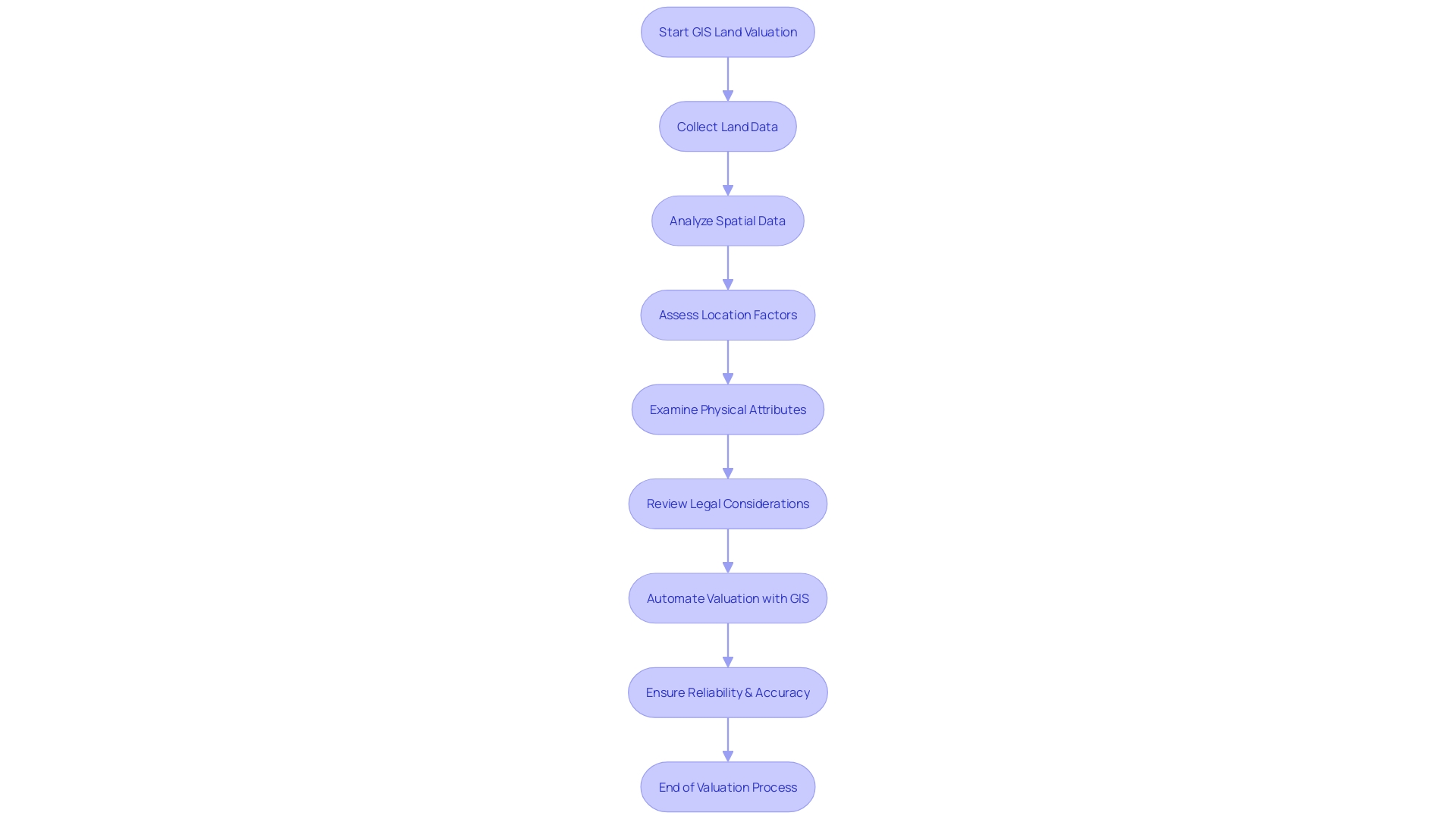
For those involved in land documentation, the integration of advanced technology has markedly improved the assessment and management of land resources. Geographical Information Systems (GIS), for example, have revolutionized the way land is valued and managed. A notable study demonstrated the efficiency of GIS in automating the land valuation process, underscoring its reliability and accuracy compared to traditional methods. This innovative approach leverages spatial analysis to consider factors such as location, physical attributes, and legal considerations, providing a unified value for land parcels.
In practice, organizations like the National Trust utilize GIS alongside other tools to manage and conserve vast expanses of land. With a portfolio that includes natural landscapes and historic sites, they harness data to monitor changes and manage resources effectively. Similarly, forest and landscape restoration projects in Kenya benefit from technology, emphasizing local empowerment—a testament to the transformative power of these tools in environmental conservation and climate action.
Open data initiatives also play a critical role in land management, as evidenced by the introduction of online tools that offer insights into environmental factors like air quality and noise levels. These tools empower not just landowners and developers but also residents and professionals in urban planning and public health by providing accessible environmental data for informed decision-making. The geospatial industry continues to grow, bridging the gap between digital and physical realms through digital twins and enhancing infrastructure management.
However, the conversation around technology and data in land management is not one-sided. Concerns have been raised about the potential for open data to exacerbate inequality. The digitization of land records in Bangalore, for example, revealed a 'data divide' where the empowered could exploit data for personal gain at the expense of the less privileged. This highlights the necessity for equitable access to data and the resources to use it effectively, ensuring that all stakeholders can benefit from the advancements in land documentation and management.

Case Studies: Successful Land Documentation Examples
The integration of open data into land administration systems holds significant potential for enhancing sustainable socio-economic and environmental management. However, this innovation carries its own set of challenges, including the risk of exacerbating inequality. In the context of land documentation, open data has been shown to have the power to both empower and disenfranchise. For example, the digitization of land records in Bangalore, India, led to an imbalance wherein more affluent individuals and corporations could exploit documentation errors and engage in opportunistic practices, often to the disadvantage of less privileged landowners.
To counteract such risks, it is crucial to ensure that open data is not just accessible, but that all users have the means and skills to leverage it effectively. A comprehensive model for effective data use should include elements such as internet access, adequate hardware and software, digital literacy, and support for interpretation and advocacy. Without these components in place, the benefits of open data may remain out of reach for underserved populations, potentially being used to their detriment.
In a proactive approach, the empowerment of vulnerable communities to manage their own data has been illustrated by initiatives among the First Nations in Canada, demonstrating how equitable access to open data can facilitate more informed decision-making and enhance the delivery of essential land-related services.
On a practical level, the importance of land surveys cannot be overstated. As experienced Realtors will attest, determining the precise location of property boundaries is paramount when transacting real estate. This process, executed by qualified surveyors, establishes property lines and maps the land's physical features, which is indispensable for preventing boundary disputes and ensuring clarity of property rights.
Globally, efforts to modernize land documentation are underway, exemplified by Uzbekistan's move to improve land accounting and cadastral services. The country's commitment to digitalization is evident in its creation of electronic maps for 96 percent of its lands and the introduction of private cadastral engineers, enhancing the quality and accessibility of cadastral services. By July 2024, a new information system, UZKAD, will be implemented, marking a significant stride towards efficient and transparent land management.
These developments and case studies underscore the transformative potential of well-maintained land documentation in facilitating equitable land transactions, supporting development, and ensuring compliance with regulatory standards.
Conclusion
Accurate land documentation is crucial for informed decision-making, property ownership affirmation, and sustainable land management. Open data initiatives have the potential to enhance land administration systems, but they also carry the risk of exacerbating social inequalities. The digitization of land records in Bangalore, India, highlighted the empowerment of privileged groups at the expense of the marginalized.
Conversely, the First Nations in Canada demonstrate how empowering vulnerable communities to manage their data can mitigate such risks.
Understanding and adhering to the legal and regulatory aspects of land documentation are essential for secure property transactions. This involves acquiring the correct types of documentation, such as land surveys, property deeds, zoning maps, and land use permits. It is crucial to navigate the multi-step process of property surveys, title searches, documentation preparation, and obtaining approvals from relevant authorities.
Land documentation is not just paperwork; it establishes property ownership and defines permissible land uses. Precise mapping of boundaries, consideration of easements, restrictions, and encumbrances are vital components. Accurate land documentation prevents legal complications and disputes.
Navigating the complexities of land documentation requires a comprehensive understanding of open data and its implications. Empowering vulnerable communities and ensuring equitable access to data are crucial to avoid exacerbating inequality.
Optimizing the organization, storage, and regular updating of land documentation is pivotal. Leveraging digital tools like Geographical Information Systems (GIS) enhances efficiency. Open data initiatives and innovative platforms support informed decision-making in land management.
In conclusion, well-maintained land documentation facilitates equitable land transactions, supports development, and ensures compliance with regulations. Understanding the importance of land documentation, legal aspects, and best practices, along with utilizing available tools and resources, is essential for navigating the complexities of land management and ensuring secure and sustainable land transactions.
Ensure secure property transactions with our comprehensive land documentation services.


