Overview
Solar resource potential mapping is crucial for assessing the availability of sunlight for renewable energy projects, thereby guiding informed land acquisition decisions. As the complexities of land acquisition often involve legal and regulatory challenges, it is imperative to have accurate assessments. Advancements in technologies such as GIS and satellite imagery significantly enhance the precision of these evaluations. This optimization not only streamlines site selection but also elevates the efficiency of energy installations. Ultimately, leveraging these technologies can lead to more strategic decisions in renewable energy development.
Introduction
Solar resource potential mapping is at the forefront of the renewable energy revolution, leveraging advanced geospatial technologies to assess sunlight availability across diverse locations. This critical data empowers stakeholders to make informed decisions that optimize site selection for solar projects, ultimately enhancing energy efficiency and reducing costs.
However, as the demand for clean energy escalates, a pressing challenge arises: how can developers effectively navigate the complexities of land acquisition while maximizing their solar resource potential?
This article explores the intricacies of solar resource potential mapping, examining its evolution, applications, and methodologies that drive successful energy development.
Define Solar Resource Potential Mapping
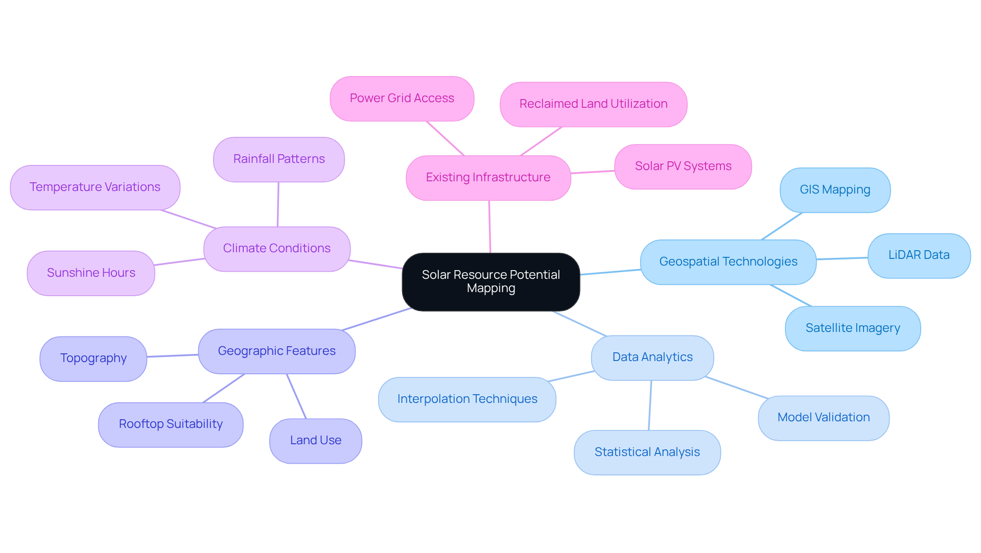
Solar resource potential mapping is a critical process for evaluating and illustrating the availability of renewable resources in specific locations. This process leverages geospatial technologies and data analytics to determine how much sunlight can be harnessed at various sites. It incorporates essential factors such as geographic features, climate conditions, and existing infrastructure.
By providing a comprehensive overview of sunlight capability, solar resource potential mapping empowers stakeholders to make informed decisions regarding site selection for renewable energy projects. This ensures optimal positioning for maximum power generation, addressing the complexities of land acquisition and regulatory challenges.
In an era where renewable energy is paramount, understanding sunlight resources is not just beneficial—it's essential. Are you ready to optimize your project’s potential? Let’s explore how we can assist you in navigating these challenges effectively.

Trace the Evolution of Solar Resource Potential Mapping
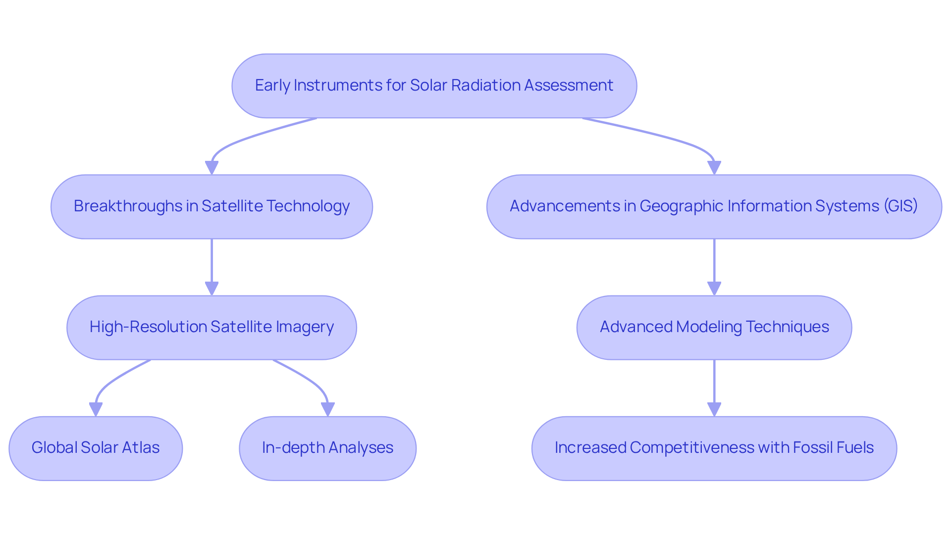
The evolution of solar resource potential mapping marks a significant advancement in energy studies, transitioning from rudimentary instruments for solar radiation assessment to sophisticated technologies. Over the decades, breakthroughs in satellite technology and Geographic Information Systems (GIS) have transformed the landscape of energy evaluation. The advent of high-resolution satellite imagery, coupled with advanced modeling techniques, has paved the way for precise assessments of energy potential.
Today, tools such as the Global Solar Atlas and various GIS-based applications enable solar resource potential mapping and in-depth analyses of sunlight resources. This development is crucial for effective planning and execution of energy projects across diverse terrains. For example, on March 11, California sourced nearly 40% of its electricity from photovoltaic systems, a testament to the successful integration of these technologies.
Moreover, the financial viability of photovoltaic power has reached a level where it competes directly with coal and natural gas in select markets. This trend signifies a broader shift towards renewable energy sources, which are projected to account for over 42% of electricity generation by 2028. Such advancements not only enhance project efficiency but also meet the growing demand for clean energy solutions, aligning with global goals for expanding renewable resource capacity.
In summary, the continuous development in solar resource potential mapping and related technologies highlights a pivotal shift in energy production, fostering a sustainable future.

Explore Applications in Energy Development and Land Acquisition
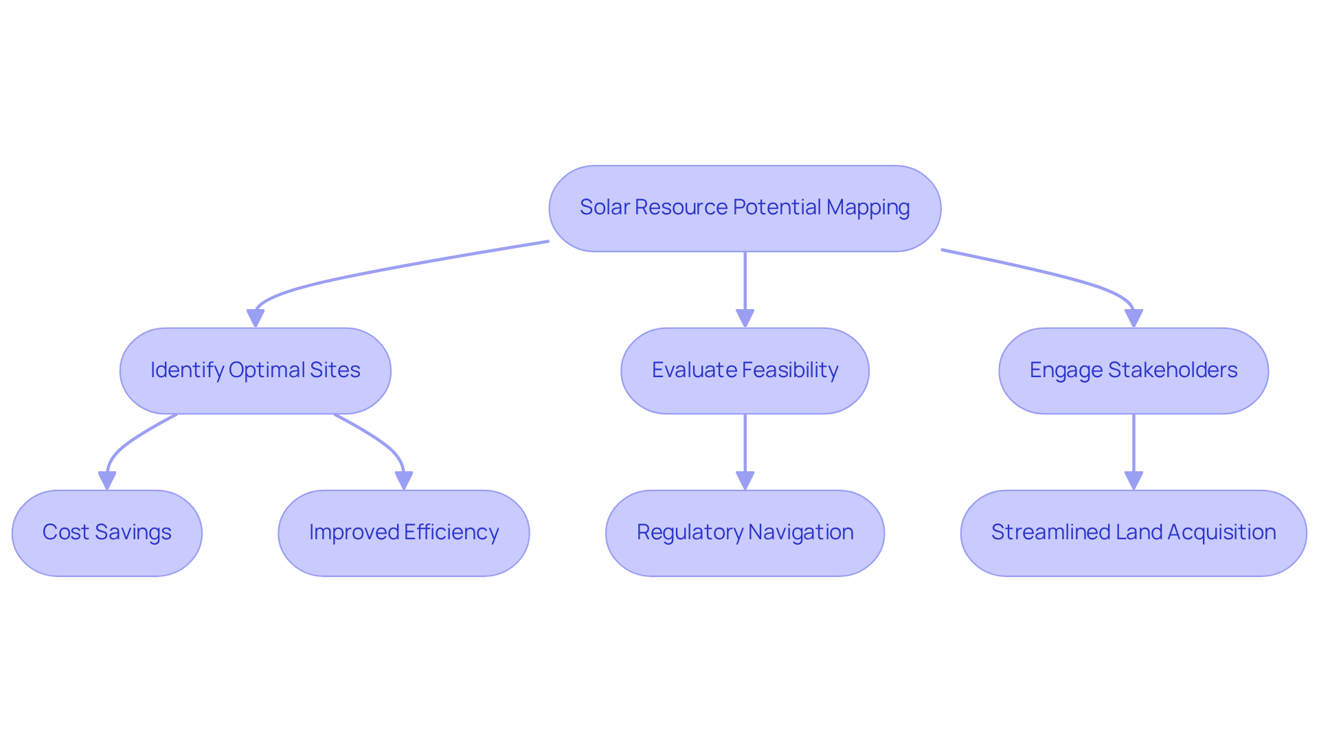
The process of solar resource potential mapping is essential for power development and land acquisition, as it provides critical data that guides site selection for photovoltaic projects. Developers rely on these maps to pinpoint areas with optimal energy potential, leading to significant cost savings and improved efficiency in energy installations. For example, municipalities and power companies can utilize sunlight mapping to evaluate the feasibility of photovoltaic farms, rooftop installations, and community solar projects. This strategic methodology not only aids in navigating regulatory requirements but also fosters effective stakeholder engagement, thereby streamlining the land acquisition process.
By utilizing solar resource potential mapping, organizations can refine their land acquisition strategies, concentrating on sites that maximize solar power production while minimizing development costs. Harbinger Land specializes in negotiating and securing the necessary leases and easements for distributed energy assets and infrastructure development. This expertise not only saves clients time and money but also enhances decisions regarding land rights. Leveraging Harbinger Land's GIS mapping and title research services, organizations can significantly elevate their land acquisition strategies.

Examine Key Characteristics and Methodologies
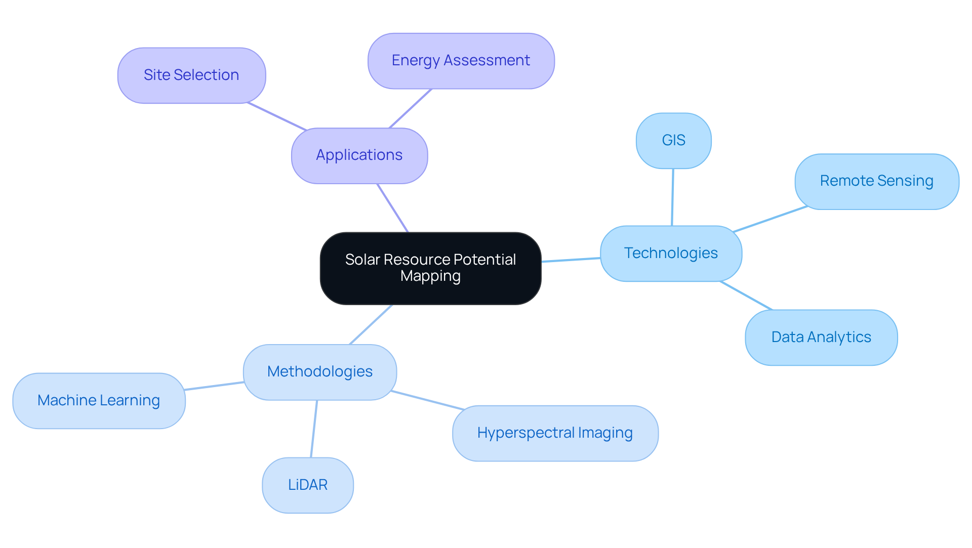
The integration of Geographic Information Systems (GIS), remote sensing technologies, and advanced data analytics is significantly enhanced by solar resource potential mapping. This integration addresses the pressing challenges of accurately assessing solar energy potential, particularly in the context of land acquisition where legal and regulatory complexities abound, by utilizing solar resource potential mapping. Key methodologies include the collection of sunlight radiation data via ground-based sensors and satellite imagery, which are meticulously processed for solar resource potential mapping to create detailed energy maps.
Techniques such as LiDAR (Light Detection and Ranging) and hyperspectral imaging are increasingly employed to enhance the precision of these assessments. Remarkably, recent studies indicate that GIS-based methods can achieve an accuracy rate of 0.87 when correlated with LiDAR data derived from various Digital Elevation Models (DEMs). This statistical evidence underscores the reliability of GIS in energy assessments.
Furthermore, the integration of machine learning algorithms facilitates predictive modeling of renewable generation. This capability empowers developers to refine site selection and project design by leveraging both historical and real-time data. The technological synergy inherent in these methodologies not only bolsters the reliability of energy assessments but also supports informed decision-making in land acquisition for renewable projects, particularly through solar resource potential mapping.
Experts in the field, including Jack Dangermond, assert that the application of GIS is limited only by the imagination of its users. This assertion highlights the transformative potential of these technologies in solar energy planning and urban sustainability. As the landscape of renewable energy continues to evolve, embracing these advanced methodologies will be pivotal for stakeholders aiming to navigate the complexities of land acquisition effectively.

Conclusion
Solar resource potential mapping is an essential tool in the renewable energy sector, providing a systematic method to assess and visualize sunlight availability across various locations. By utilizing advanced geospatial technologies and data analytics, this process not only informs stakeholders but also strategically positions energy projects for maximum efficiency while ensuring compliance with regulatory frameworks.
The evolution of solar resource potential mapping has progressed from its early stages to the current advanced methodologies, which include the integration of GIS and remote sensing technologies. Accurate data collection and analysis are crucial for facilitating land acquisition and optimizing energy project development. Tools like the Global Solar Atlas have become indispensable for developers, enabling cost-effective site selection and enhancing stakeholder engagement.
As the world increasingly embraces renewable energy solutions, the adoption of solar resource potential mapping is imperative. Stakeholders must leverage these innovative methodologies to navigate the complexities of land acquisition and contribute to a sustainable energy future. Investing in these technologies not only supports the transition to cleaner energy but also aligns with global goals for expanding renewable resource capacity, ensuring a greener tomorrow for all.
Frequently Asked Questions
What is solar resource potential mapping?
Solar resource potential mapping is the process of evaluating and illustrating the availability of renewable solar resources in specific locations using geospatial technologies and data analytics.
Why is solar resource potential mapping important?
It is important because it helps stakeholders make informed decisions about site selection for renewable energy projects, ensuring optimal positioning for maximum power generation.
What factors are considered in solar resource potential mapping?
The factors considered include geographic features, climate conditions, and existing infrastructure.
How does solar resource potential mapping assist in project development?
It provides a comprehensive overview of sunlight capability, which addresses complexities related to land acquisition and regulatory challenges in renewable energy projects.
Why is understanding sunlight resources essential in today's context?
Understanding sunlight resources is essential because renewable energy is becoming increasingly important, and optimizing project potential is crucial for effective energy generation.
List of Sources
- Define Solar Resource Potential Mapping
- Assessing Solar Photovoltaic Potential Using LiDAR and GIS Modeling (https://link.springer.com/10.1007/978-3-030-72579-2_114)
- GIS-Based Solar Radiation Mapping, Site Evaluation, and Potential Assessment: A Review (https://mdpi.com/2076-3417/9/9/1960)
- Assessment of solar resource potential and estimation of direct and diffuse solar irradiation from sunshine hours data for Eastern Zone of Tigray, Northern Ethiopia - Sustainable Energy Research (https://sustainenergyres.springeropen.com/articles/10.1186/s40807-025-00162-2)
- Solar resource maps & GIS data for 200+ countries | Solargis (https://solargis.com/resources/free-maps-and-gis-data?locality=usa)
- Solar Resource Data, Tools, and Maps | Geospatial Data Science | NREL (https://nrel.gov/gis/solar)
- Trace the Evolution of Solar Resource Potential Mapping
- Renewable energy - Wikiquote (https://en.wikiquote.org/wiki/Renewable_energy)
- Quotes About Solar Power: 50 Picks to Light Up Your Life - Lumify Energy (https://lumifyenergy.com/blog/quotes-about-solar-power)
- Solar Resource Maps and Data | Geospatial Data Science | NREL (https://nrel.gov/gis/solar-resource-maps)
- Top Solar Quotes (https://inventionsolar.com/solar-quotes)
- Explore Applications in Energy Development and Land Acquisition
- Top Ten Quotes about Solar Power (https://harnessoursun.com/top-ten-quotes-about-solar-power)
- Solar Industry Research Data – SEIA (https://seia.org/research-resources/solar-industry-research-data)
- Quotes About Solar Power: 50 Picks to Light Up Your Life - Lumify Energy (https://lumifyenergy.com/blog/quotes-about-solar-power)
- Top 19 solar energy statistics [UK & worldwide, 2025] (https://sunsave.energy/solar-panels-advice/solar-energy/statistics)
- Examine Key Characteristics and Methodologies
- GIS-Based Solar Radiation Mapping, Site Evaluation, and Potential Assessment: A Review (https://mdpi.com/2076-3417/9/9/1960)
- Improving the resolution of solar energy potential maps derived from global DSMs for rooftop solar panel placement using deep learning (https://sciencedirect.com/science/article/pii/S2405844024172246)
- Quotes About Solar Power: 50 Picks to Light Up Your Life - Lumify Energy (https://lumifyenergy.com/blog/quotes-about-solar-power)
- Assessing Solar Photovoltaic Potential Using LiDAR and GIS Modeling (https://link.springer.com/10.1007/978-3-030-72579-2_114)
- GIS and Cartography Quotes (https://geographyrealm.com/gis-quotes)


