Overview
The article presents a compelling overview of seven key strategies essential for successful coastal erosion risk mapping. It highlights the critical role of:
- Advanced technologies
- Stakeholder engagement
- Comprehensive data collection
Evidence supporting these strategies underscores their effectiveness in pinpointing vulnerable areas and facilitating informed decision-making. This process is vital for crafting robust management and mitigation plans to combat coastal erosion.
Introduction
As coastal regions confront the relentless forces of nature and human impact, the urgency for effective risk mapping has reached critical levels. Coastal erosion not only jeopardizes the integrity of ecosystems but also threatens the livelihoods of communities reliant on these delicate environments. Harbinger Land is at the forefront of addressing this challenge, utilizing advanced Geographic Information Systems (GIS) and AI-driven title research to illuminate the vulnerabilities of coastlines worldwide. By integrating cutting-edge technology with meticulous data analysis, stakeholders are empowered to make informed decisions that can mitigate risks and protect coastal assets.
This article delves into the multifaceted approaches to coastal erosion risk mapping, examining the causes and impacts of erosion, innovative methodologies, and the essential role of community engagement in crafting sustainable solutions. With the stakes higher than ever, understanding these dynamics is crucial for safeguarding our coasts for future generations.
Harbinger Land: Advanced GIS and Title Research for Coastal Erosion Risk Mapping
Harbinger Land employs advanced Geographic Information Systems (GIS) and AI-driven title research to address the pressing issue of coastal erosion risk mapping. This innovative approach facilitates meticulous data collection and analysis, which are crucial for identifying vulnerable coastal regions and developing effective mitigation strategies. By leveraging GIS technology, Harbinger Land can accurately visualize degradation patterns and assess associated risks, equipping stakeholders with essential insights for informed decision-making.
Recent studies reveal that 50.75 km of surveyed shoreline is classified as highly vulnerable, underscoring the urgent need for precise mapping and proactive management. As Alan Pickaver noted, "In the coming millennium, demands on water resources will increase, as will the levels of pollutants," highlighting the critical necessity for effective management strategies in the face of shoreline erosion. Moreover, successful applications of AI in shoreline evaluations have demonstrated significant enhancements in efficiency and accuracy, reinforcing the importance of integrating these technologies into sustainable infrastructure projects.
As urbanization and tourism continue to exert pressure on coastal landscapes, the role of international collaboration in developing effective policies becomes increasingly vital. This collaboration ensures that ecosystems are preserved and restored for future generations. To capitalize on these advancements, stakeholders should actively consider implementing GIS and AI technologies in their coastal erosion risk mapping efforts, fostering a proactive approach to managing these critical challenges.
Understanding Coastal Erosion: Causes and Impacts
Coastal degradation presents a significant challenge, primarily driven by natural forces such as wave action and rising sea levels, alongside human activities like construction and sand mining. In 2025, statistics reveal that approximately 40% of the U.S. coastline is experiencing considerable degradation, with certain areas losing up to 10 feet of land annually. This alarming trend leads to severe consequences, including land loss, infrastructure damage, and detrimental effects on local ecosystems.
Environmental scientists assert that the dynamics of shoreline erosion are intricate, often worsened by climate change, which disrupts weather patterns and heightens the frequency of extreme weather events. Deepti Singh, Ph.D., emphasizes, "At this point, we have very clear evidence that human activities are warming the planet, and that global warming is affecting us here in the U.S. today." This statement underscores the critical relationship between human actions and the challenges faced by coastal regions.
For instance, effective dune management has proven to enhance resilience against storm impacts, illustrating the necessity of recognizing the ecological importance of these natural barriers. Community responses to shoreline erosion typically involve collaborative initiatives aimed at restoring and safeguarding marine habitats, demonstrating that proactive measures can alleviate the economic repercussions on infrastructure and local economies.
Furthermore, the long-term monitoring of shoreline changes, particularly in tourism-centric areas like Konyaaltı beach, is vital for coastal erosion risk mapping and informing hazard assessment strategies. As coastal regions continue to confront these challenges, comprehensive vulnerability assessment strategies, such as coastal erosion risk mapping, become essential for safeguarding both communities and ecosystems.
Key Methodologies in Coastal Erosion Risk Mapping
Efficient assessment mapping for coastal degradation is essential for coastal erosion risk mapping and relies on a fusion of advanced techniques, including remote sensing technologies, GIS analysis, and field surveys. Remote sensing tools, such as satellite imagery and LiDAR, provide extensive data on shoreline dynamics, enabling the monitoring of changes over time. These technologies have demonstrated significant effectiveness, with studies indicating that remote sensing can enhance assessment accuracy by up to 30%.
GIS analysis is crucial for coastal erosion risk mapping, as it integrates various data layers to identify areas most susceptible to degradation. This method offers a comprehensive view of the landscape, facilitating informed decision-making. Field surveys serve as an essential supplement to these techniques, providing ground-truthing data that ensures the reliability of assessments.
As Stewart Rowe, Chair of the Coastal Group Network, notes, "The revised information on shoreline deterioration will be essential for the execution of the Shoreline Management Plans that outline our long-term strategy for handling flooding and shoreline deterioration around the coast." This underscores the necessity of employing advanced methodologies within sustainable infrastructure projects.
Moreover, the forthcoming revised Flood Zone Data (NaFRA2), set for release on 25 March 2025, will aid developers and planners in assessing flood hazards more effectively, ensuring they have the most current information for planning objectives. By integrating these approaches, experts can achieve a robust understanding of shoreline degradation risks, which is vital for coastal erosion risk mapping and ultimately leads to more sustainable infrastructure design and oversight.
Data Collection Techniques for Coastal Erosion Assessments
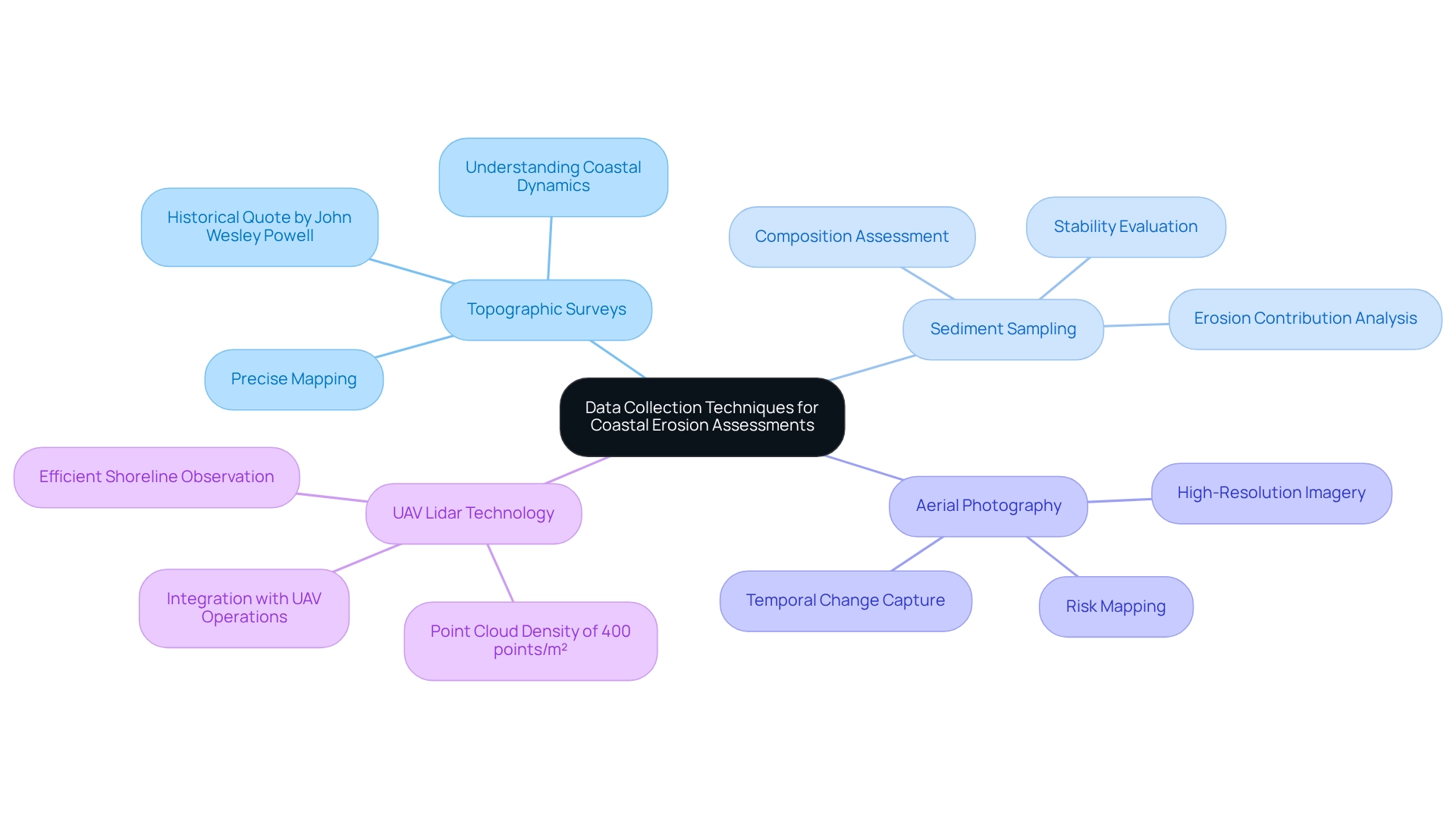
Effective data gathering methods for shoreline degradation evaluations encompass topographic surveys, sediment sampling, and aerial photography. Topographic surveys are indispensable, delivering precise information about shoreline landforms that facilitate accurate mapping and examination of wear patterns. As John Wesley Powell, the second director of the U.S. Geological Survey, asserted, "A Government cannot do any scientific work of more value to the people at large than by causing the construction of proper topographic maps of the country." This statement underscores the critical role of topographic surveys in understanding coastal dynamics.
Sediment sampling is vital for assessing the composition and stability of beach materials, which is crucial for comprehending how these elements contribute to erosion challenges. Aerial photography, particularly when enhanced by drone technology, provides high-resolution imagery that captures temporal changes in the coastline, which offers invaluable data for coastal erosion risk mapping and comprehensive risk assessments.
Furthermore, the incorporation of UAV Lidar technology, as illustrated in the DEM’EAUX project, signifies a remarkable achievement in environmental surveying, attaining a point cloud density of 400 points/m², which is especially efficient for observing shoreline regions. Such advancements emphasize the necessity of employing diverse data gathering techniques to ensure thorough evaluations of shoreline degradation.

Engaging Stakeholders in Coastal Erosion Risk Mapping
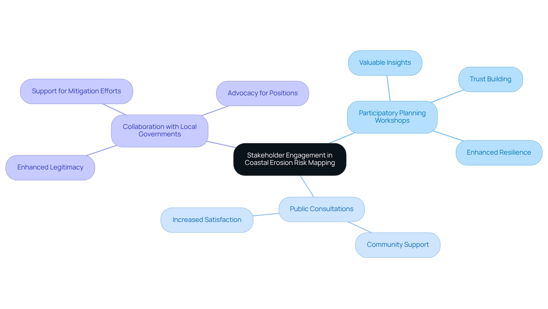
Involving stakeholders in coastal erosion risk mapping is crucial for effectively addressing the specific needs and concerns of local communities. Effective strategies encompass:
- Participatory planning workshops
- Public consultations
- Collaboration with local governments and organizations
These initiatives not only gather valuable insights but also foster community support and enhance the legitimacy of risk assessments. Successful participatory mapping initiatives in shoreline communities, as documented in various case studies, demonstrate that when stakeholders are actively engaged, the resulting data is more precise and representative of local conditions.
Statistics indicate that communities with high levels of stakeholder involvement in shoreline erosion evaluations report greater satisfaction with the outcomes and increased readiness to assist in mitigation efforts. Experts emphasize that community engagement is not merely beneficial but essential for the success of evaluations, leading to more sustainable and accepted solutions.
Furthermore, participatory planning workshops have proven effective in building trust and cooperation among diverse stakeholder groups, ultimately enhancing the resilience of marine infrastructure. As Jane Jacobs astutely noted, 'Cities have the capability of providing something for everybody, only because, and only when, they are created by everybody.' This underscores the vital role of community involvement in shaping effective solutions.
Additionally, stakeholder engagement is paramount for marine conservation and economic development efforts, highlighting the significance of participation in the context of coastal erosion risk mapping. Financial support for professional negotiators can further assist stakeholder groups in advocating for their positions in discussions related to shoreline degradation, reinforcing the necessity for robust engagement strategies.

Technological Innovations in Coastal Erosion Risk Mapping
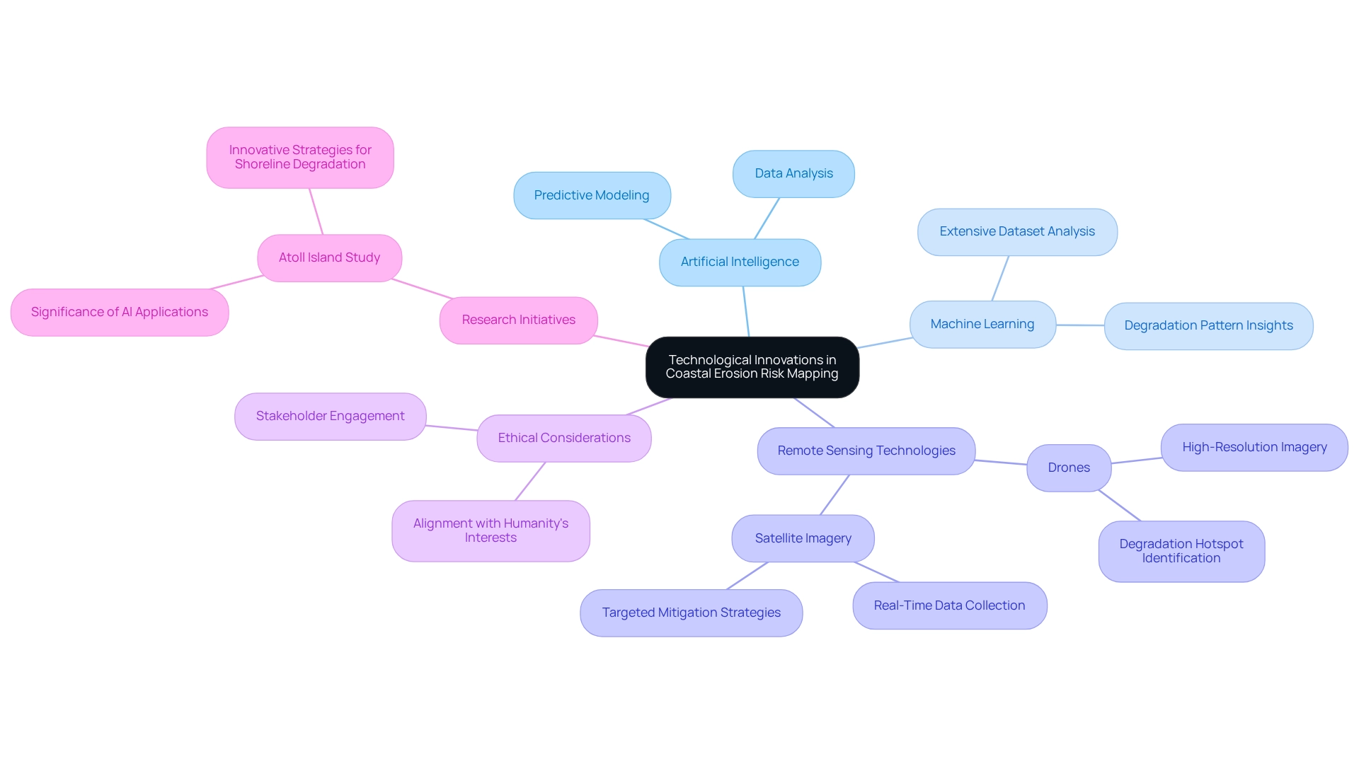
Recent advancements in coastal erosion risk mapping are significantly driven by artificial intelligence (AI) and machine learning technologies. These innovations enable predictive modeling that enhances the precision of forecasting deterioration trends and evaluating vulnerabilities in real-time. Machine learning algorithms analyze extensive datasets, providing detailed insights into degradation patterns and potential impacts.
Moreover, the integration of remote sensing technologies, such as drones and satellite imagery, has transformed data collection. These tools deliver high-resolution imagery that identifies degradation hotspots, allowing for targeted mitigation strategies.
As Bernard Marr, a leading business influencer, observes, "AI is transforming how we approach environmental challenges, providing tools that enhance our understanding and response capabilities." Additionally, Satya Nadella underscores the importance of ethical considerations in AI development, asserting that solutions must align with humanity's best interests. This ethical framework is crucial as stakeholders leverage these technologies to effectively safeguard shoreline infrastructure and ecosystems.
Notably, a recent research initiative conducted by a university on an atoll island highlights the growing significance of AI applications in environmental data analysis, underscoring the necessity for coastal erosion risk mapping and innovative strategies to address shoreline degradation.

Policy Frameworks for Coastal Erosion Risk Management
Efficient risk management for shoreline degradation requires robust policy frameworks that incorporate coastal erosion risk mapping to promote sustainable practices and strengthen community resilience. Strong policies, such as the Coastal Zone Management Act (CZMA), in conjunction with local land-use regulations, play a crucial role in directing development and conservation efforts along coastlines. The CZMA has demonstrated its effectiveness in steering shoreline projects, with statistics revealing that jurisdictions under its purview have experienced a notable reduction in erosion rates compared to those lacking such oversight.
Moreover, the 2025 Notification Direction mandates that Local Planning Authorities (LPAs) notify Welsh Ministers of applications for Highly Vulnerable Development on previously undeveloped land within Flood Zone 3 within a 21-day notification period. This requirement underscores the regulatory framework's influence on coastal development. Stakeholders must remain vigilant in understanding these policies to ensure their assessment initiatives not only comply with regulatory standards but also contribute significantly to long-term management objectives.
Recent case studies, including the Environment Agency's £200 million Flood and Coastal Innovation Programmes, exemplify how innovative strategies can enhance community resilience against climate change impacts. As Rebecca Evans MS remarked, this represents a landmark moment for Welsh planning policy, highlighting the importance of making informed decisions based on the best available evidence. Aligning hazard assessment initiatives with these frameworks is essential for coastal erosion risk mapping and effective shoreline management.
Furthermore, insights from Derek Brockbank emphasize that undermining federal consistency could allow the federal government to act without regard for regional communities, further reinforcing the necessity of cohesive policy frameworks.
Case Studies: Successful Coastal Erosion Risk Mapping Initiatives
Successful shoreline deterioration hazard assessment projects illustrate effective strategies and methodologies. Notably, the National Coastal Erosion Risk Mapping project in the U.S. employs advanced GIS techniques, facilitating a comprehensive evaluation of degradation risks across multiple states. This initiative has enabled targeted interventions and resulted in significant funding distributions aimed at mitigating the impact of land degradation, culminating in the first nationally consistent hazard maps for England and Wales.
Additionally, community-driven charting efforts in seaside towns have proven highly beneficial. By actively engaging local residents, these projects have pinpointed vulnerable areas and crafted tailored mitigation strategies that address the unique needs of each community. For instance, in Point Hope, the design of a safe boat ramp for subsistence hunting was shaped by interviews with community members, ensuring the ramp met practical needs while considering environmental impacts.
As Russel Lane, a Point Hope resident and village services supervisor, noted, a hunter indicated that ice cellars should be constructed in locations with fine soil grain size, underscoring the necessity of a grain-size assessment for soil in the ice cellar region.
These case studies underscore the critical importance of collaboration among government, industry, and academia in addressing challenges through coastal erosion risk mapping and other aspects of coastal degradation. The fusion of local insight with scientific study not only enhances the efficiency of cartographic efforts but also fosters community resilience against the repercussions of degradation.
Challenges in Coastal Erosion Risk Mapping
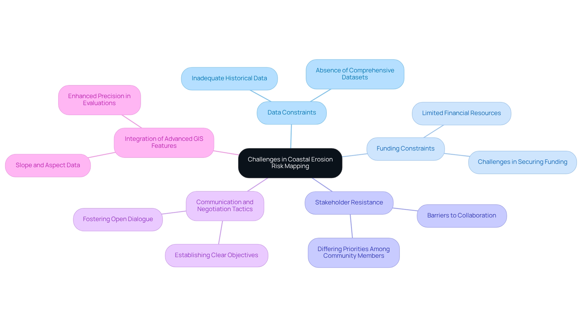
Coastal erosion risk mapping encounters significant obstacles that can impede effective evaluations and management approaches. A primary challenge is data constraints; often, historical data proves inadequate for generating reliable predictions, resulting in uncertainties that jeopardize decision-making. A project aimed at developing a robust and consistent probabilistic method for coastal erosion risk mapping has been initiated, yet its effectiveness is frequently compromised by the absence of comprehensive datasets.
Funding constraints further complicate these initiatives. In economically constrained areas, securing financial resources for extensive surveying projects poses particular challenges, thereby limiting the scope and accuracy of assessments. This issue is exacerbated by stakeholder resistance, as differing priorities and concerns among community members can create barriers to collaboration. Efficient communication and negotiation tactics, such as establishing clear objectives and fostering open dialogue, are essential for engaging stakeholders and aligning their interests with the goals of mapping initiatives.
Moreover, specialist perspectives stress that without addressing these data constraints and financial hurdles, the capacity to effectively conduct coastal erosion risk mapping and manage shoreline challenges remains impaired. As Shannon Hulst, an expert in floodplain and community rating systems, articulates, "When we are aware that there is a threat, and that is what we were using as the best available information to guide us about that threat, it makes it challenging to manage our communities to the fullest of our capability."
Integrating advanced GIS features, as illustrated in the case study on slope and aspect data, can enhance the precision of shoreline degradation evaluations by providing valuable insights into land management and environmental assessment. In conclusion, addressing these challenges requires innovative financing strategies and improved data gathering techniques to ensure that shoreline degradation vulnerability assessments effectively inform community planning and resilience initiatives.

Future Trends in Coastal Erosion Risk Mapping
Future trends in coastal erosion risk mapping will be significantly influenced by technological progress, increased community involvement, and changing regulatory structures. The integration of artificial intelligence and machine learning is set to revolutionize predictive capabilities, enabling more accurate assessments of erosion threats. As Rachael Shwom, Ph.D., aptly states, "Climate change is absolutely impacting different groups of people in different ways," which underscores the disproportionate effects on vulnerable communities. This reality highlights the critical need for community input and resilience in planning, especially as adaptive management strategies become more prominent.
Moreover, the Alliance of CEO Climate Leaders has demonstrated that companies can achieve a 9% reduction in emissions, illustrating how technology is being harnessed in the broader context of climate change and environmental management. Policymakers must revise regulations to reflect the dynamic nature of shoreline environments, ensuring that they effectively address the challenges posed by climate change.
The case study on 'Environmental Inequality and Climate Change' reveals how inadequate infrastructure exacerbates flooding and human suffering in communities already burdened by high levels of environmental pollution. This holistic approach not only enhances the precision of risk evaluations but also fosters a collaborative atmosphere where communities can actively engage in shaping their futures.
To effectively engage communities, stakeholders should prioritize inclusive dialogues that address local concerns and incorporate diverse perspectives into coastal management strategies.
Conclusion
The multifaceted approaches to coastal erosion risk mapping highlight the urgent necessity for effective strategies to address the escalating threats from both natural forces and human activities. Advanced technologies, such as Geographic Information Systems (GIS) and artificial intelligence, are proving crucial in pinpointing vulnerable areas and delivering data-driven insights that empower stakeholders to make informed decisions. Furthermore, integrating community engagement into these mapping initiatives significantly enhances their effectiveness, ensuring that local knowledge and needs are prioritized in developing sustainable solutions.
As coastal regions confront substantial challenges—ranging from land loss to infrastructure damage—the significance of comprehensive risk assessments cannot be overstated. Engaging stakeholders through participatory mapping and collaboration builds trust and facilitates the creation of tailored mitigation strategies that reflect the realities of each community. Successful case studies further illustrate the value of merging scientific research with local expertise, reinforcing the idea that collaborative efforts are vital for fostering resilience against coastal erosion.
Looking ahead, the future of coastal erosion risk mapping will depend on continuous advancements in technology, policy frameworks, and community involvement. Embracing these trends will not only enhance predictive capabilities but also ensure that the voices of those most affected by coastal changes are heard and integrated into management strategies. By prioritizing innovation and inclusivity, stakeholders can protect coastal ecosystems and livelihoods for generations to come, ultimately cultivating a more sustainable and resilient coastal future.
Frequently Asked Questions
What technologies does Harbinger Land use for coastal erosion risk mapping?
Harbinger Land employs advanced Geographic Information Systems (GIS) and AI-driven title research to facilitate meticulous data collection and analysis for coastal erosion risk mapping.
Why is accurate coastal erosion risk mapping important?
Accurate mapping is crucial for identifying vulnerable coastal regions, developing effective mitigation strategies, and equipping stakeholders with essential insights for informed decision-making.
What recent findings highlight the urgency of coastal erosion management?
Recent studies indicate that 50.75 km of surveyed shoreline is classified as highly vulnerable, emphasizing the need for precise mapping and proactive management as coastal degradation continues to rise.
How does urbanization and tourism affect coastal landscapes?
Urbanization and tourism exert pressure on coastal landscapes, necessitating international collaboration to develop effective policies for preserving and restoring ecosystems for future generations.
What are the primary causes of coastal degradation?
Coastal degradation is driven by natural forces such as wave action and rising sea levels, as well as human activities like construction and sand mining.
What are the consequences of shoreline erosion?
Shoreline erosion leads to severe consequences, including land loss, infrastructure damage, and detrimental effects on local ecosystems.
How does climate change influence shoreline erosion?
Climate change disrupts weather patterns and increases the frequency of extreme weather events, exacerbating the dynamics of shoreline erosion.
What role do community initiatives play in addressing shoreline erosion?
Community responses typically involve collaborative initiatives aimed at restoring and safeguarding marine habitats, which can alleviate the economic repercussions on infrastructure and local economies.
What methodologies are used for efficient assessment mapping of coastal degradation?
Efficient assessment mapping relies on a fusion of advanced techniques including remote sensing technologies, GIS analysis, and field surveys.
How can remote sensing technologies enhance coastal erosion assessments?
Remote sensing tools, such as satellite imagery and LiDAR, provide extensive data on shoreline dynamics, enhancing assessment accuracy by up to 30%.
What is the significance of field surveys in coastal erosion risk mapping?
Field surveys provide ground-truthing data that ensures the reliability of assessments, complementing remote sensing and GIS analysis.
What upcoming data release will aid in assessing flood hazards?
The forthcoming revised Flood Zone Data (NaFRA2), set for release on March 25, 2025, will help developers and planners assess flood hazards more effectively.
List of Sources
- Harbinger Land: Advanced GIS and Title Research for Coastal Erosion Risk Mapping
- (PDF) The determination of coastal sensitivity indices for Cocos and Columbus bays, Trinidad using GIS multi-criteria analysis (https://researchgate.net/publication/366182289_The_determination_of_coastal_sensitivity_indices_for_Cocos_and_Columbus_bays_Trinidad_using_GIS_multi-criteria_analysis)
- (PDF) The Benefits of Inter-linking Coastal and River Management: Case Study 20 - Balancing upstream economic activities with coastal sustainable development in the Oder river basin, Germany and Poland (https://researchgate.net/publication/257870271_The_Benefits_of_Inter-linking_Coastal_and_River_Management_Case_Study_20_-_Balancing_upstream_economic_activities_with_coastal_sustainable_development_in_the_Oder_river_basin_Germany_and_Poland)
- mdpi.com (https://mdpi.com/2073-445X/9/8/275)
- Understanding Coastal Erosion: Causes and Impacts
- Beach Erosion - an overview | ScienceDirect Topics (https://sciencedirect.com/topics/agricultural-and-biological-sciences/beach-erosion)
- Coastal Erosion - an overview | ScienceDirect Topics (https://sciencedirect.com/topics/social-sciences/coastal-erosion)
- Fifth National Climate Assessment: Quotes from Authors - SciLine (https://sciline.org/climate/fifth-national-climate-assessment-quotes-from-authors)
- Key Methodologies in Coastal Erosion Risk Mapping
- Updates to Flood and Coastal Erosion Risk Information - McCloy Consulting (https://mccloyconsulting.com/updates-to-flood-and-coastal-erosion-risk-information)
- Risk assessment of coastal erosion (https://gov.uk/flood-and-coastal-erosion-risk-management-research-reports/risk-assessment-of-coastal-erosion)
- The Environment Agency's new map tool is transforming shoreline management (https://government-transformation.com/transformation/the-environment-agencys-new-map-tool-is-transforming-shoreline-management)
- Environment Agency publishes major update to national flood and coastal erosion risk assessment (https://preventionweb.net/news/environment-agency-publishes-major-update-national-flood-and-coastal-erosion-risk-assessment)
- Data Collection Techniques for Coastal Erosion Assessments
- Monitoring Coastal Erosion with UAV Lidar (https://gim-international.com/content/article/monitoring-coastal-erosion-with-uav-lidar)
- Geology Quotes - 240 quotes on Geology Science Quotes - Dictionary of Science Quotations and Scientist Quotes (https://todayinsci.com/QuotationsCategories/G_Cat/Geology-Quotations.htm)
- USGS Topographer at Work with JW Powell Quote (https://usgs.gov/media/images/usgs-topographer-work-jw-powell-quote)
- Engaging Stakeholders in Coastal Erosion Risk Mapping
- Stakeholder Engagement Strategy - Shoreline Management Plan (https://northsolentsmp.co.uk/article/2572/Stakeholder-Engagement-Strategy)
- Step 4. Engaging stakeholders – MSPGLOBAL2030 (https://mspglobal2030.org/resources/key-msp-references/step-by-step-approach/engaging-stakeholders)
- Quotes about community action and the power of community (https://appropedia.org/Quotes_about_community_action_and_the_power_of_community)
- researchgate.net (https://researchgate.net/figure/Examples-of-quotes-translation-from-the-stakeholders-interviews-into-variables-and_fig1_329774803)
- Technological Innovations in Coastal Erosion Risk Mapping
- Scientists combine AI and climate data to create a warning tool for coastal flooding (https://plymouth.ac.uk/news/scientists-combine-ai-and-climate-data-to-create-a-warning-tool-for-coastal-flooding)
- 28 Best Quotes About Artificial Intelligence | Bernard Marr (https://bernardmarr.com/28-best-quotes-about-artificial-intelligence)
- 15 Quotes on the Future of AI (https://time.com/partner-article/7279245/15-quotes-on-the-future-of-ai)
- Policy Frameworks for Coastal Erosion Risk Management
- New TAN15 2025: Flood & Planning Policy Update | Unda (https://unda.co.uk/news/new-tan15-2025-flood-planning-policy-update)
- Environment Agency publishes major update to national flood and coastal erosion risk assessment (https://preventionweb.net/news/environment-agency-publishes-major-update-national-flood-and-coastal-erosion-risk-assessment)
- Coastal States Organization Opposes Bill Attacking Coastal Zone Management Act - Coastal States Organization (https://coastalstates.org/coastal-states-organization-opposes-bill-attacking-coastal-zone-management-act)
- Case Studies: Successful Coastal Erosion Risk Mapping Initiatives
- TEK Case Study: Improving Coastal Resilience in Point Hope, Alaska – EDM (https://edm-1.itrcweb.org/tek-case-study-improving-coastal-resilience-in-point-hope-alaska)
- National coastal erosion risk mapping the first national run (https://researchgate.net/publication/269117382_National_coastal_erosion_risk_mapping_the_first_national_run)
- Challenges in Coastal Erosion Risk Mapping
- (PDF) Coastal erosion mapping and management (https://researchgate.net/publication/284099745_Coastal_erosion_mapping_and_management)
- Risk assessment of coastal erosion (https://gov.uk/flood-and-coastal-erosion-risk-management-research-reports/risk-assessment-of-coastal-erosion)
- FEMA quietly removes access to New England coastal erosion hazard tool • Rhode Island Current (https://rhodeislandcurrent.com/2025/04/11/fema-quietly-removes-access-to-new-england-coastal-erosion-hazard-tool)
- Future Trends in Coastal Erosion Risk Mapping
- Quotes on the future of our ocean from Queen Noor of Jordan, Marc Benioff and more (https://weforum.org/stories/2020/06/quotes-ocean-future-environment-climate-change)
- Fifth National Climate Assessment: Quotes from Authors - SciLine (https://sciline.org/climate/fifth-national-climate-assessment-quotes-from-authors)
- 30 of the Most Impactful Climate Change Quotes - Curious Earth (https://curious.earth/blog/climate-change-quotes)


